
Lake Tahoe
USGS / TRPA / Federal Water Master • Built 1913 • 122,000 surface acres • 72 miles shoreline
Lake Tahoe
Great Day on the Water
Level is right at normal conservation pool (-0.9 ft), water temp is cold at 40°f, light winds around 0 mph, no active algae or safety advisories.
What to Know About Lake Tahoe
The largest alpine lake in North America and second deepest in the US (1,645 ft). Water clarity is legendary at 70+ feet deep. Emerald Bay with Vikingsholm Castle and Fannette Island is an international bucket-list destination.
Boat Ramps & Launches
Public concrete launches, usable lake elevations, and federal pass info🚤 Angora Ridge
Usable (Level OK)Public boat launch facility providing direct water access with vehicle and boat trailer parking.
🚤 Bayview / Inspiration Point Day Use
Usable (Level OK)Public boat launch facility providing direct water access with vehicle and boat trailer parking.
🚤 Brockway Summit/Martis Peak
Usable (Level OK)Brockway Summit/Martis Peak
🚤 Buck Lake Road 14N40
Usable (Level OK)Public boat launch facility providing direct water access with vehicle and boat trailer parking.
🚤 Cascade Falls
Usable (Level OK)The trail starts at the Bayview Trailhead on the back side of Bayview Campground. The round-trip to the falls is not in Desolation Wilderness, so no permit is needed. The trail is public, but Cascade Lake itself is a pri...
🚤 Desolation Wilderness Permit
Usable (Level OK)With numerous alpine lakes, scenic waterfalls and towering granite peaks, Desolation Wilderness is a perfect location for a summer trip. Whether you want an arduous climb or a relaxing walk, you'll find what yo...
🚤 Eagle Falls Trailhead
Usable (Level OK)Public boat launch facility providing direct water access with vehicle and boat trailer parking.
🚤 Fountain Place
Usable (Level OK)Public boat launch facility providing direct water access with vehicle and boat trailer parking.
🚤 Glen Alpine Trailhead
Usable (Level OK)Public boat launch facility providing direct water access with vehicle and boat trailer parking.
🚤 Kings Beach 18E18
Usable (Level OK)Public boat launch facility providing direct water access with vehicle and boat trailer parking.
🚤 Kiva Picnic Area
Usable (Level OK)Kiva picnic area is situated on the south shore of beautiful Lake Tahoe on Highway 89 approximately three miles northwest of the City of South Lake Tahoe. Nestled among native pine trees, Kiva picnic area offers a quiet ...
🚤 Lake Tahoe - South Shore
Usable (Level OK)The south shore of Lake Tahoe is located on the California side of the lake with the main access via Highways 50 and 89. The south shore boasts a spectrum of commercial development intermixed with recreational opportunit...
🚤 Lake Tahoe - West Shore
Usable (Level OK)The west shore of Lake Tahoe is located on the California side of the lake. Highway 89 stretches along this side of the lake with access via Highway 50 to the south and Interstate 80 to the north. Recreational opportunit...
🚤 Lake Tahoe Basin Management Unit Christmas Tree Permit
Usable (Level OK)Public boat launch facility providing direct water access with vehicle and boat trailer parking.
🚤 Loon Lake Day Use And Boat Launch
Usable (Level OK)Public boat launch facility providing direct water access with vehicle and boat trailer parking.
🚤 Mckinney/Rubicon Trailhead
Usable (Level OK)Directions to the trailhead: From Highway 89, south of Homewood, turn west onto McKinney Rubicon Springs Road. Take the first left on Bellevue and then the second right on McKinney Road (follow signs to Miller Lake). Mak...
🚤 Meeks Bay Trailhead
Usable (Level OK)Public boat launch facility providing direct water access with vehicle and boat trailer parking.
🚤 Mt. Rose Summit Interpretive Site
Usable (Level OK)Public boat launch facility providing direct water access with vehicle and boat trailer parking.
🚤 Mt. Watson 73E
Usable (Level OK)Public boat launch facility providing direct water access with vehicle and boat trailer parking.
🚤 Nevada Beach Pavilion
Usable (Level OK)Public boat launch facility providing direct water access with vehicle and boat trailer parking.
🚤 Page Meadow
Usable (Level OK)Public boat launch facility providing direct water access with vehicle and boat trailer parking.
🚤 Power Line Road 12N08
Usable (Level OK)Public boat launch facility providing direct water access with vehicle and boat trailer parking.
🚤 Sand Pit 12N28
Usable (Level OK)Public boat launch facility providing direct water access with vehicle and boat trailer parking.
🚤 Saxon Creek
Usable (Level OK)Public boat launch facility providing direct water access with vehicle and boat trailer parking.
🚤 Stateline Lookout
Usable (Level OK)Public boat launch facility providing direct water access with vehicle and boat trailer parking.
🚤 Valhalla
Usable (Level OK)The Heller Estate, located east of the Pope and Baldwin estates, is known as Valhalla, which means Viking heaven. Valhalla is located on National Forest land and is operated under a special use permit by Valhalla Tahoe (...
Campgrounds & RV Parks
Official federal, Corps of Engineers & state park campsites⛺ Alpine Meadow Campground
$18 - $32 / nightLocated close to Lake Tahoe, Truckee, and Reno, Martis has a beautiful, peaceful campground off the beaten path. Martis Creek area features hiking, biking, canoeing, kayaking, and catch and release trout fishing...
⛺ Badgers Den At Camp Richardson Resort
$18 - $32 / nightBadger’s Den Campground provides a Lake Tahoe and Camp Richardson Resort experience unlike any other. Featuring beach access, and all the amenities you can think of within walking distance, guests get to bask in...
⛺ Eagles Nest At Camp Richardson Resort
$18 - $32 / nightEagles Nest Campground provides a Lake Tahoe and Camp Richardson Resort experience unlike any other. Featuring beach access, and all the amenities you can think of within walking distance, guests get to bask in ...
⛺ Fallen Leaf Campground
$18 - $32 / nightFallen Leaf Campground is situated on the north shore of Fallen Leaf Lake and adjacent to Taylor Creek. The south shore of Lake Tahoe is less than a mile away. The campground features 206 sites that include six ...
⛺ Goose Meadows
$18 - $32 / nightGoose Meadow Campground is located along the Truckee River adjacent to Highway 89, about half-way between Tahoe City and Truckee. Visitors enjoy the area for its fishing and hiking opportunities, as well as its ...
⛺ Granite Flat (California)
$18 - $32 / nightGranite Flat Campground is located between the Truckee River and Highway 89, just one mile from Truckee and a short distance from Tahoe City. Visitors enjoy the area for its fishing and hiking opportunities, as ...
⛺ Hope Valley
$18 - $32 / nightHope Valley Campground is located in its beautiful namesake valley at an elevation of 7,300 feet, just 40 minutes south of Lake Tahoe. Visitors enjoy fishing the West Fork Carson River and exploring local trails...
⛺ Kaspian Campground
$18 - $32 / nightKaspian Campground is located in a mature forest of pine trees overlooking the beautiful Lake Tahoe. Campers will be nestled in a sparse forest of pine trees and evergreen shrubs, just minutes from the bright bl...
⛺ Loon Lake
$18 - $32 / nightLoon Lake Campground is situated on the south shores of Loon Lake, and attracts many visitors with its variety of campsites and beautiful waterfront setting. Popular activities include boating, swimming, fishing...
⛺ Loon Lake Chalet
$18 - $32 / nightLoon Lake Chalet is situated next to Loon Lake in a granite bowl, and offers year-round, drive-to access for excellent backcountry skiing and hiking. The three-story chalet boasts excellent views of the Sierras ...
⛺ Meeks Bay Resort
$18 - $32 / nightNO PETS ARE ALLOWED ANYWHERE AT THE RESORT! Meeks Bay Resort has a long tradition as a family vacation and holiday retreat. It is located on western shore of the famed Lake Tahoe (Da ow aga), far away from the h...
⛺ Mount Rose (Nv)
$18 - $32 / nightMount Rose Campground is conveniently located between Reno and Lake Tahoe just off scenic Mount Rose Highway. Visitors love the campground for its proximity to excellent hiking trails and recreational opportunit...
⛺ Nevada Beach Campground
$18 - $32 / nightNevada Beach Campground sits in the Lake Tahoe Basin of Nevada. Minutes from the bright blue water of Tahoe's eastern shores, campsites are nestled in a sparse forest of pine trees and evergreen shrubs. The lake...
⛺ Northshore Campground
$18 - $32 / nightNorthshore Campground Recreation Opportunity Guide (ROG) - This guide contains information, maps, and directions to assist you in enjoying your trip to the Eldorado National Forest.
⛺ Northshore Campground - Loon Lake (Ca)
$18 - $32 / night23 miles east of Placerville on Highway 50 and 31 miles north on Ice House Road (Forest Road 3), take the Loon Lake fork. Recreation Swimming and Fishing Boat Ramp at Loon Lake Campground Picnic Area (5 sites) a...
⛺ Pleasant Campground
$18 - $32 / nightSmall boat or hike in campground on the east shore of Loon Lake campground. Access via the Loon Lake Trailhead or boatramp at Loon Lake Campground. Pleasant Campground Recreation Opportunity Guide (ROG) - This guide cont...
⛺ Red Fir
$18 - $32 / nightSituated on the north side of the Loon Lake Reservoir, Red Fir Group Campground offers a primitive group camping experience in the lush Eldorado National Forest. Recreation The nearby lake provides fishing, swim...
⛺ Rv Village Campground At Camp Richardson Resort
$18 - $32 / nightThe RV Village provides a Lake Tahoe and Camp Richardson Resort experience unlike any other. Featuring beach access, and all the amenities you can think of within walking distance, guests get to bask in the rema...
⛺ Silver Creek-Truckee
$18 - $32 / nightSilver Creek Campground is located on the Truckee River, off of Highway 89, between Truckee and Tahoe City. Visitors enjoy the area for its fishing and hiking opportunities, as well as its proximity to Lake Taho...
⛺ Upper Hole Campground
$18 - $32 / nightThis facility is only accessible by boat or trail. Location: 22 miles east of Georgetown on Wentworth Springs Road, and 29 miles northeast on Forest Highway 2 (Eleven Pines road) to Hell Hole Reservoir, then 3 miles sout...
⛺ Wentworth Springs Campground
$18 - $32 / nightWentworth Springs Campground Recreation Opportunity Guide (ROG) - This guide contains information, maps, and directions to assist you in enjoying your trip to the Eldorado National Forest.
⛺ William Kent Campground
$18 - $32 / nightWilliam Kent Campground is conveniently located on Lake Tahoe's west shore, a few miles south of Tahoe City. It straddles the highway and features not only a large area in which to camp, but also a day-use area ...
⛺ Zephyr Cove Rv & Campground
$18 - $32 / nightLake Tahoe is one of the most stunning destinations on the planet, making it a top choice for outdoor enthusiasts who enjoy RV cruising and camping. Zephyr Cove Resort's award-winning RV Park & Campground provid...
Today's Fishing Outlook
Favorable feeding forecast today with the First Quarter (56% illuminated). Surface water is 40°F with a steady pool (-0.01' in 24h). Fish will feed aggressively along windblown points and main-lake humps during the primary major window.
Fishing Regulations & Species
State Wildlife AgencyLicense Info: Valid CA or NV license honored anywhere on the lake.
Regulations Summary: Mackinaw reach 20-30 lbs in deep water (150-300 ft).
View Official Wildlife Department Regulations →Lake Rules & Boating Safety
Strict TRPA watercraft inspection mandatory prior to launching. Cold water immersion safety strictly advised.
Recent Community Reports
Real-time water clarity, hazards, and ramp wait times shared by boaters and anglers.
No community reports submitted in the last 24 hours for Lake Tahoe
Were you on the water today? Share water clarity, ramp conditions, or hazards to help fellow lake visitors.
Spaceborne Satellite Observation & Water Clarity
Fresh multi-spectral overhead Earth observation from the European Space Agency (ESA) Sentinel-2 constellation (10m spatial resolution).
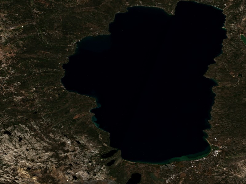
Satellite imagery and indices processed via Copernicus Data Space Ecosystem (CDSE) / Sentinel Hub API. Data reflects actual surface conditions at the time of orbital passage.
Derived from Band 4 red reflectance across open water pixels. Low reflectance indicates minimal suspended silt and high underwater visibility for angling and navigation.
Normalized Difference Chlorophyll Index (NDCI: -0.006) measures phytoplankton concentration using Red-Edge (B05) and Red (B04) bands to detect early bloom development before surface scums appear.
Normalized Difference Water Index (NDWI) contrasts Green and Near-Infrared spectra to map shallow shoals, sandbars, and exposed islands (like Sometimes Island on Travis or Wood Island on Texoma).
Recommended Gear for Current Conditions
Algorithmically matched to today's water temperature (40°F), lake elevation, and weather forecast.
O'Neill Men's Reactor-2 3/2mm Back Zip Full Wetsuit
Water temperature is a chilly 40°F. Rapid immersion risks cold shock; 3/2mm FluidFlex neoprene maintains vital core body warmth.
Onyx A/M-24 Deluxe Automatic/Manual Inflatable Life Jacket (USCG)
Lightweight, comfortable low-profile design that automatically inflates upon immersion while allowing full arm mobility for driving and casting.
Earth Pak 20L Waterproof Heavy Duty Dry Bag with Phone Case
500D commercial grade PVC keeps phones, dry clothes, first-aid, and towels 100% dry through boat wake spray and sudden rain squalls.
Amarine Made Stainless Steel Boat Rod Holder
Heavy-duty stainless steel bracket allows hands-free trolling and live-bait spread drifting with secure angle locking.
Commercial Marinas & Featured Partners on Lake Tahoe
Verified marine operators, boat slip facilities, and licensed guide services.
⚓ Badgers Den At Camp Richardson Resort
Badger’s Den Campground provides a Lake Tahoe and Camp Richardson Resort experience unlike any other. Featuring beach access, and all the amenities you can think of within walking distance, guests get to bask in...
⚓ Eagles Nest At Camp Richardson Resort
Eagles Nest Campground provides a Lake Tahoe and Camp Richardson Resort experience unlike any other. Featuring beach access, and all the amenities you can think of within walking distance, guests get to bask in ...
Charter Guide or Boat Rental on Lake Tahoe?
Reach thousands of visiting boaters and anglers checking live water levels, surface temperatures, and ramp conditions before heading to Lake Tahoe.
Living on Lake Tahoe
Considering buying a lake cabin, dockable waterfront home, or retirement property on Lake Tahoe? Water levels, dock stability, and flood pool buffers are critical factors in waterfront valuation.
Lake Tahoe Dam in Tahoe City controls upper 6.1 feet of reservoir storage feeding the Truckee River into Reno.
South Lake Tahoe, CA
Bustling ski hub at Heavenly Mountain, sandy beaches, marinas, and vibrant border nightlife.
Incline Village, NV
Prestigious Nevada North Shore enclave, private resident beaches, golf, and tax advantages.
Tahoe City, CA
Historic western gateway where the Truckee River outlet begins, pedestrian village and piers.
Kings Beach, CA
Sunny northern shore town known for expansive sandy public beaches, dining, and paddleboarding.
Truckee, CA
Vibrant mountain town north of the lake with historic rail heritage, dining, and Donner Lake access.