Lake Havasu
Bureau of Reclamation • Built 1938 • 19,300 surface acres • 450 miles shoreline
Lake Havasu
Notice / Caution Recommended
Level is 1.2 ft below normal pool, water temp is a comfortable 88°f, light winds around 2 mph, active watch algae advisory.
What to Know About Lake Havasu
Home to the original 1831 London Bridge, dismantled and shipped stone-by-stone from England in 1968. The Bridgewater Channel is the undisputed social epicenter of Southwest boating.
Boat Ramps & Launches
Public concrete launches, usable lake elevations, and federal pass info🚤 Quail Hollow Day Use Area
Usable (Level OK)Quail Hollow Day Use Area is situated along the California-side of the lower Colorado River within the Parker Strip Recreation Area . This site provides river access, shaded picnic tables, and a vault toilet. Visitors en...
🚤 Take Off Point
Usable (Level OK)Take Off Point provides free public fishing and boating access to Lake Havasu. Take Off Point includes parking, restaurants and universally accessible fishing docks. A valid Arizona fishing license is required for Arizon...
Campgrounds & RV Parks
Official federal, Corps of Engineers & state park campsites⛺ Lake Havasu Shoreline Sites
$18 - $32 / nightThe Lake Havasu Field Offices manages 73 boat access campsites over 20 miles along the Arizona shore of Lake Havasu. These campsites offer a picnic table, barbecue grill, and trash receptacle and a majority of the sites ...
Today's Fishing Outlook
Conditions favor patience today under First Quarter (56% illuminated). With water at 88°F and steady pool (-0.01' in 24h), focus presentations near deep drop-offs and brush piles during minor activity windows.
Fishing Regulations & Species
State Wildlife AgencyLicense Info: AZ or CA fishing license with Colorado River stamp.
Regulations Summary: World record 5.8-pound redear sunfish caught here.
View Official Wildlife Department Regulations →Lake Rules & Boating Safety
No-wake idle speed strictly enforced through Bridgewater Channel.
Recent Community Reports
Real-time water clarity, hazards, and ramp wait times shared by boaters and anglers.
No community reports submitted in the last 24 hours for Lake Havasu
Were you on the water today? Share water clarity, ramp conditions, or hazards to help fellow lake visitors.
Spaceborne Satellite Observation & Water Clarity
Fresh multi-spectral overhead Earth observation from the European Space Agency (ESA) Sentinel-2 constellation (10m spatial resolution).
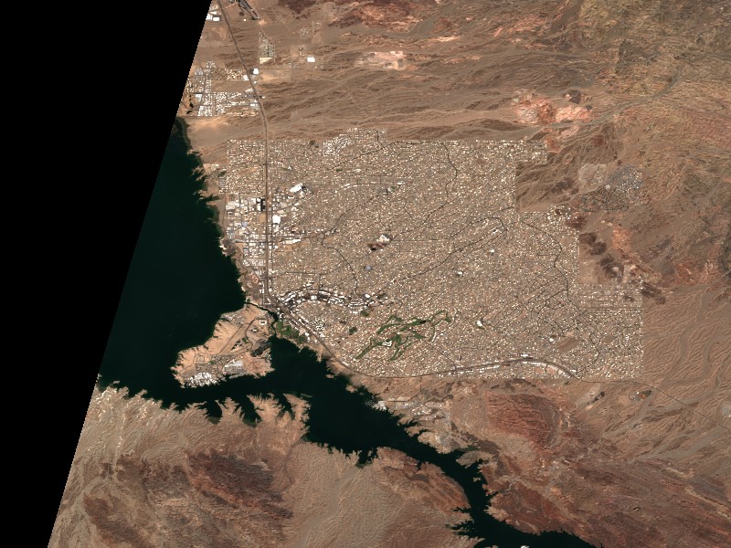
Satellite imagery and indices processed via Copernicus Data Space Ecosystem (CDSE) / Sentinel Hub API. Data reflects actual surface conditions at the time of orbital passage.
Derived from Band 4 red reflectance across open water pixels. Low reflectance indicates minimal suspended silt and high underwater visibility for angling and navigation.
Normalized Difference Chlorophyll Index (NDCI: -0.107) measures phytoplankton concentration using Red-Edge (B05) and Red (B04) bands to detect early bloom development before surface scums appear.
Normalized Difference Water Index (NDWI) contrasts Green and Near-Infrared spectra to map shallow shoals, sandbars, and exposed islands (like Sometimes Island on Travis or Wood Island on Texoma).
Recommended Gear for Current Conditions
Algorithmically matched to today's water temperature (88°F), lake elevation, and weather forecast.
Airhead Super Mable 3-Rider Towable Tube with Dual Tow Points
Warm 88°F surface water offers perfect conditions for wake tubing, chariot riding, and family towing action.
Onyx A/M-24 Deluxe Automatic/Manual Inflatable Life Jacket (USCG)
Lightweight, comfortable low-profile design that automatically inflates upon immersion while allowing full arm mobility for driving and casting.
SereneLife 10'6" Inflatable Stand Up Paddleboard (Complete Kit)
Calm winds (2 mph) offer pristine mirror-calm coves for touring, paddleboard fitness, and shoreline exploration.
Garmin Striker 4 Fishfinder with CHIRP Sonar & Dual-Beam Transducer
High-frequency CHIRP sonar pinpoints submerged humps, river channel dropoffs, bait balls, and suspended gamefish with crisp target separation.
Commercial Marinas & Featured Partners on Lake Havasu
Verified marine operators, boat slip facilities, and licensed guide services.
Featured Fishing Guides on Lake Havasu
Are you a licensed fishing guide or charter captain on Lake Havasu? Feature your guide service at the top of our daily solunar fishing forecast and water report.
Marinas & Boat Rentals on Lake Havasu
Connect directly with lake homeowners and visiting boaters searching for pontoon rentals, boat slips, dry storage, and marine service.
Living on Lake Havasu
Considering buying a lake cabin, dockable waterfront home, or retirement property on Lake Havasu? Water levels, dock stability, and flood pool buffers are critical factors in waterfront valuation.
Parker Dam maintains remarkably stable pool within 3-5 feet year round.
Lake Havasu City, AZ
Boating lifestyle capital with RV garages, palm trees, London Bridge, and waterfront dining.
Needles, CA
Historic Route 66 town along the Colorado River, gateway to Topock Gorge and northern lake waters.
Parker, AZ
Southern Colorado River corridor renowned for the Parker Strip floating bars and tube floating.
Desert Hills, AZ
Quiet residential desert foothill enclave just north of Havasu with oversized boat garage estates.