
Lake Shasta
Bureau of Reclamation (Central Valley Project) • Built 1945 • 30,000 surface acres • 365 miles shoreline
Lake Shasta
Notice / Caution Recommended
Level is 24.6 ft below normal pool (watch for shallow hazards), water temp is 62°f (crisp), light winds around 2 mph, no active algae or safety advisories.
What to Know About Lake Shasta
Known as the Houseboating Capital of the World. Four picturesque river arms (Sacramento, McCloud, Pit, Squaw Creek) surrounded by evergreen Shasta-Trinity National Forest with Mount Shasta visible to the north.
Boat Ramps & Launches
Public concrete launches, usable lake elevations, and federal pass info🚤 Bailey Cove Public Boat Ramp
Low Water CautionLocated on the lower McCloud River Arm in the Bailey Cove facilities area. There are two launching lanes available until the lake level drops to 50 feet. Picnicking, restrooms, fee. (Not recommended on summer weekends du...
🚤 Centimudi Public Boat Ramp
Low Water CautionLocated near Shasta Dam, the Centimudi ramp has four launching lanes available for varying lake levels; a four lane ramp with a courtesy dock is available when lake draw down is between 0 and 75 feet, a three lane ramp i...
🚤 Clear Creek Greenway
Low Water CautionThe Clear Creek Greenway offers hiking, biking, horseback riding, wildlife viewing and swimming all within a short drive from Redding. Horsetown Clear Creek Preserve is managed cooperatively with a private non-profit gro...
🚤 Dekkas Rock Day Use Area
Low Water CautionThe Dekkas Rock Day Use and Picnic area is located on Gilman Road about 11 miles east of Interstate 5 on Gilman Road between the Hirz Bay Campground and the Dekkas Rock Group Campground. This picnic area provides access ...
🚤 Fishermans Point Day Use Area
Low Water CautionThe Fisherman's Point Day Use and Picnic area is located near Shasta Dam. Exit I-5 at Shasta Dam Boulevard. You will come to a four-way stop after you go through the City of Shasta Lake. Turn right and follow Lake Boulev...
🚤 Hirz Bay Public Boat Ramp
Low Water CautionLocated on the McCloud Arm of Shasta Lake, the Hirz Bay boat ramp is paved and has three (3) ramps for varying lake levels. A three lane ramp is in service until 75 feet drawdown, a two lane ramp until 95 feet drawdown. ...
🚤 Jones Valley Public Boat Ramp
Low Water CautionLocated on the Pit River Arm of Shasta Lake, the Jones Valley Boat Ramp is paved and has four (4) ramps for varying lake levels. A four lane ramp is available until 50 feet of lake drawdown, a two lane ramp is available ...
🚤 Livingston Stone National Fish Hatchery
Low Water CautionLivingston Stone National Fish Hatchery was established in 1997 and located at the base of Shasta Dam. Livingston Stone National Fish Hatchery is the only hatchery in the world that raises listed winter-run Chinook salmo...
🚤 Packers Bay Public Boat Ramp
Low Water CautionLocated on the Sacramento Arm of Shasta Lake, the Packers Bay boat ramp is paved. It has four lanes available until 50 feet of drawdown, and then has two lanes available until 115 feet of drawdown. Open all year, this ra...
🚤 Shasta Lake Area
Low Water Caution** Due to fluctuating water levels on Shasta Lake, visitors are encouraged to contact the Shasta Recreation Company (concessionaire to the Forest Service) @ 530-275-8113 or the Shasta-Triinity National Forest, Shasta Lak...
🚤 Shasta-Trinity National Forest - Antlers Boat Ramp
Low Water CautionPublic boat launch facility providing direct water access with vehicle and boat trailer parking.
🚤 Shasta-Trinity National Forest - Bailey Cove Boat Ramp
Low Water CautionPublic boat launch facility providing direct water access with vehicle and boat trailer parking.
🚤 Shasta-Trinity National Forest - Centimudi Boat Ramp
Low Water CautionPublic boat launch facility providing direct water access with vehicle and boat trailer parking.
🚤 Shasta-Trinity National Forest - Hirz Bay Boat Ramp
Low Water CautionPublic boat launch facility providing direct water access with vehicle and boat trailer parking.
🚤 Shasta-Trinity National Forest - Jones Valley Boat Ramp
Low Water CautionPublic boat launch facility providing direct water access with vehicle and boat trailer parking.
🚤 Shasta-Trinity National Forest - Packers Bay Boat Ramp
Low Water CautionPublic boat launch facility providing direct water access with vehicle and boat trailer parking.
🚤 Shasta-Trinity National Forest - Sugarloaf Boat Ramp
Low Water CautionPublic boat launch facility providing direct water access with vehicle and boat trailer parking.
🚤 Whiskeytown Firewood Collection Pass
Low Water CautionPublic boat launch facility providing direct water access with vehicle and boat trailer parking.
🚤 Whiskeytown Visitor Center
Low Water CautionThe Visitor Center is a great place to start when you arrive in the park. Knowledgeable staff can help you maximize your visit. The Visitor Center is located at the intersection of Kennedy Memorial Drive and Highway 299....
Campgrounds & RV Parks
Official federal, Corps of Engineers & state park campsites⛺ Antlers (Shasta Lake, Ca)
$18 - $32 / nightAntlers Campground is situated on a bluff above the Sacramento arm of Shasta Lake. The campground has beautiful views of the lake. There is no access to the water from this campground. The Public Boat Launch is ...
⛺ Bailey Cove
$18 - $32 / nightBailey Cove Campground is nestled in a forested area on the McCloud Arm of Shasta Lake. The site is a popular destination due to its convenient access from I-5 and the adjacent public boat ramp. The area surroun...
⛺ Beehive Dispersed Area (Ca)
$18 - $32 / nightBeehive Dispersed Camping/Day Use Area is located on the Sacramento River Arm of Shasta Lake, it has trash and portable restrooms provided in season. This is a shoreline area and doesn't have designated sites. T...
⛺ Brandy Creek Primitive Campground
$18 - $32 / nightThis campground is located in Whiskeytown National Recreation Area,19 miles west of Redding, California, and three and a half hours north of Sacramento. You can hear the waters of Brandy Creek from each campsite...
⛺ Crystal Creek Primitive Campground
$18 - $32 / nightThis tent-only campground is located in the northwest corner of Whiskeytown National Recreation Area, 19 miles west of Redding, California, and three and a half hours north of Sacramento. Crystal Creek flows alo...
⛺ Dekkas Rock
$18 - $32 / nightDekkas Rock Campground provides scenic views of the mountainous shoreline from the McCloud Arm of Lake Shasta. This group campground offers sites adjacent to the lake and is open for reservations year-round. Rec...
⛺ Dry Creek Group Campground (Whiskeytown Nra)
$18 - $32 / nightThis tent-only group campground is located on the southern shore of Whiskeytown Lake in Whiskeytown National Recreation Area, 14 miles west of Redding, California and three hours north of Sacramento. The cool, c...
⛺ Ellery Creek
$18 - $32 / nightEllery Creek is located on the McCloud Arm of Shasta Lake. The campground is terraced, providing views of the lake from all of the lower sites and some of the upper sites. At certain water levels, boats can be m...
⛺ Gregory Beach Dispersed Area (Ca)
$18 - $32 / nightGregory Beach Camping/Day Use Area is located on the Sacramento River Arm of Shasta Lake, it has trash and portable restrooms provided in season. This is a shoreline area and doesn't have designated sites. This ...
⛺ Gregory Creek Group Campground
$18 - $32 / nightThe campground is a single loop and is moderately to thickly wooded with a mix of oak and pine trees that provide plenty of shade in the hot summers (80% + cover). The understory, which consists of manzanita, blackberrie...
⛺ Hirz Bay
$18 - $32 / nightHirz Bay Campground is nestled among Manzanita and oak trees on a hilltop overlooking the McCloud Arm of Shasta Lake. The scenic location offers a variety of recreational activities, including a nearby boat ramp...
⛺ Hirz Bay Group 1
$18 - $32 / nightThe Hirz Bay Group 1 Campground sits on the McCloud Arm of Shasta Lake in a forest of oak and Manzanita. A variety of recreational activities are offered here, including a nearby boat ramp for water sports and a...
⛺ Hirz Bay Group 2
$18 - $32 / nightHirz Bay Group 2 Campground sits along the McCloud Arm of Shasta Lake, shaded by a forest of oak and Manzanita. The facility offers a variety of recreational activities, including a nearby boat ramp for water sp...
⛺ Hirz Cabin
$18 - $32 / nightHirz Cabin is nestled among manzanita and oak trees on a hilltop overlooking the McCloud Arm of Shasta Lake. The scenic location offers a variety of recreational activities, including a nearby boat ramp for wate...
⛺ Hirz Mountain Lookout
$18 - $32 / nightThe McCloud River Wintu tribe held Hirz Mountain in reverence and had a name for it in their own language. But it was a white miner, Henry Hirz, who gave the mountain its modern name. Hirz was a gold miner who l...
⛺ Horse Camp Primitive Campground
$18 - $32 / nightThis campground is located in the southeast corner of Whiskeytown National Recreation Area, 15 miles west of Redding, California, and three and a half hours north of Sacramento. This is the only campground in th...
⛺ Jones Valley Inlet Dispersed Area (Ca)
$18 - $32 / nightJones Valley Inlet Dispersed/Day Use Area is located on the Pit River Arm of Shasta Lake, it has trash and portable restrooms provided in season. This is a shoreline area and doesn't have designated sites. This ...
⛺ Jones Valley Inlet West Dispersed Area (Ca)
$18 - $32 / nightJones Valley Inlet West Dispersed/Day Use Area is located on the Pit River Arm of Shasta Lake, it has trash and portable restrooms provided in season. This is a shoreline area and doesn't have designated sites. ...
⛺ Lakeshore East
$18 - $32 / nightLakeshore East sits along the shore of the Sacramento Arm of Shasta Lake. The facility is partially shaded by oak and pine and provides some privacy between sites with an undergrowth of grass and raspberry bushe...
⛺ Lower Jones Valley (Ca)
$18 - $32 / nightLower Jones Valley Campground is located on the Pit River Arm of Shasta Lake, it has trash service, vault toilets and potable water. This is campground has 9 single sites and 2 double sites with an average back ...
⛺ Mariners Point Group Campground
$18 - $32 / nightMariners Point Campground is located where the Pit and Squaw arm of Shasta Lake come together and offers sites to both tent and RV campers. Visitors to this area can enjoy boating and fishing at the nearby Shast...
⛺ Mccloud Bridge
$18 - $32 / nightMcCloud Bridge Campground is located on the McCloud Arm of Shasta Lake, it has a total of 14 sites; 3 double sites and 11 single sites with an average back in around 35ft. This campground has vault restrooms and...
⛺ Moore Creek
$18 - $32 / nightMoore Creek Campground is situated on the McCloud Arm of Shasta Lake. This cozy campground is partially shaded and can accommodate both tents and RVs. Camping at Moore Creek provides easy access to a variety of ...
⛺ Nelson Point
$18 - $32 / nightNelson Point Campground is situated along the Sacramento Arm of Shasta Lake, easily accessible from 1-5 and located nearby many other recreation areas on Shasta Lake. Recreation The nearest public boat ramp is 6...
⛺ Peltier Bridge Primitive Campground
$18 - $32 / nightThis tent-only campground is located in the southeast corner of Whiskeytown National Recreation Area, 13.5 miles west of Redding, California, and three and a half hours north of Sacramento. Clear Creek flows pas...
⛺ Pine Point (Shasta Lake, Ca)
$18 - $32 / nightPine Point Campground is situated along the McCloud Arm of Shasta Lake and offers sites to both tent and RV campers. Visitors to this area can enjoy boating and fishing at the nearby Shasta Lake or hiking around...
⛺ Salt Creek Dispersed Area (Ca)
$18 - $32 / nightSalt Creek Camping/Day Use Area is located on the Sacramento River Arm of Shasta Lake, it has trash and portable restrooms provided in season. This is a shoreline area and doesn't have designated sites. This Cam...
⛺ Sheep Camp Primitive Campground
$18 - $32 / nightThis tent-only campground is located in the center of Whiskeytown National Recreation Area, 17 miles west of Redding, California, and three and a half hours north of Sacramento. Ponderosa pines and fir shade the...
⛺ Whiskey Creek Group Picnic Area (Whiskeytown Nra)
$18 - $32 / nightWhiskey Creek Group Picnic Area is located on the northern shore of Whiskeytown Lake in Whiskeytown National Recreation Area, 13 miles west of Redding, California. The Group Picnic Area is a popular spot to cele...
Today's Fishing Outlook
Favorable feeding forecast today with the First Quarter (56% illuminated). Surface water is 62°F with a steady pool (-0.01' in 24h). Fish will feed aggressively along windblown points and main-lake humps during the primary major window.
Fishing Regulations & Species
State Wildlife AgencyLicense Info: CDFW California sport fishing license.
Regulations Summary: Renowned for trophy spotted bass and deep-water trolling for salmon.
View Official Wildlife Department Regulations →Lake Rules & Boating Safety
All California Department of Boating and Waterways laws apply. USFS campfire permits required.
Recent Community Reports
Real-time water clarity, hazards, and ramp wait times shared by boaters and anglers.
No community reports submitted in the last 24 hours for Lake Shasta
Were you on the water today? Share water clarity, ramp conditions, or hazards to help fellow lake visitors.
Spaceborne Satellite Observation & Water Clarity
Fresh multi-spectral overhead Earth observation from the European Space Agency (ESA) Sentinel-2 constellation (10m spatial resolution).
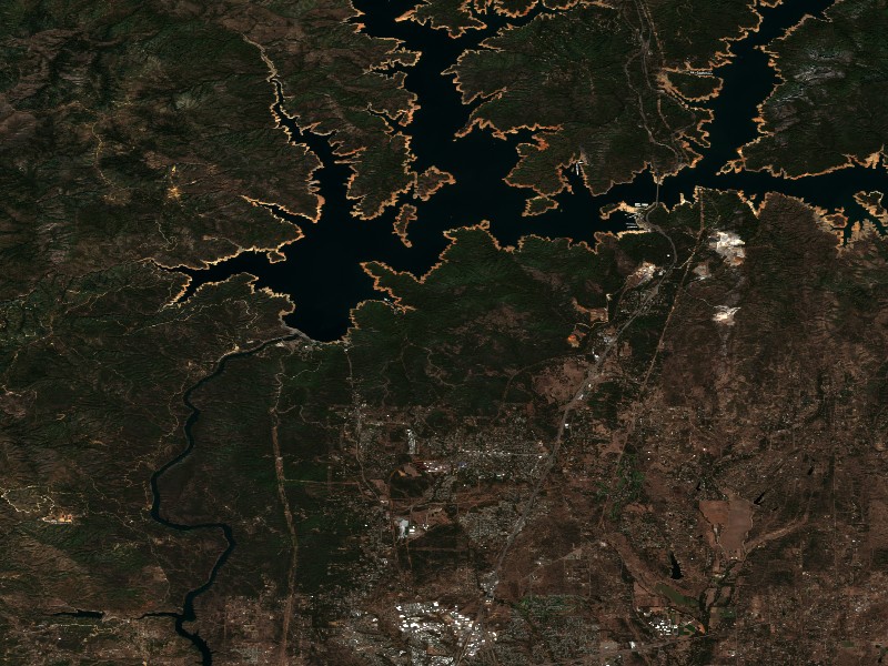
Satellite imagery and indices processed via Copernicus Data Space Ecosystem (CDSE) / Sentinel Hub API. Data reflects actual surface conditions at the time of orbital passage.
Derived from Band 4 red reflectance across open water pixels. Low reflectance indicates minimal suspended silt and high underwater visibility for angling and navigation.
Normalized Difference Chlorophyll Index (NDCI: -0.562) measures phytoplankton concentration using Red-Edge (B05) and Red (B04) bands to detect early bloom development before surface scums appear.
Normalized Difference Water Index (NDWI) contrasts Green and Near-Infrared spectra to map shallow shoals, sandbars, and exposed islands (like Sometimes Island on Travis or Wood Island on Texoma).
Recommended Gear for Current Conditions
Algorithmically matched to today's water temperature (62°F), lake elevation, and weather forecast.
O'Neill Men's Reactor-2 3/2mm Back Zip Full Wetsuit
Water temperature is a chilly 62°F. Rapid immersion risks cold shock; 3/2mm FluidFlex neoprene maintains vital core body warmth.
Taylor Made Products Low Freeboard Boat Fender & Dock Bumper
Lake is 24.6 ft low; exposed slips and low shorelines risk heavy hull scrapes from wake surges.
SereneLife 10'6" Inflatable Stand Up Paddleboard (Complete Kit)
Calm winds (2 mph) offer pristine mirror-calm coves for touring, paddleboard fitness, and shoreline exploration.
Garmin Striker 4 Fishfinder with CHIRP Sonar & Dual-Beam Transducer
High-frequency CHIRP sonar pinpoints submerged humps, river channel dropoffs, bait balls, and suspended gamefish with crisp target separation.
Commercial Marinas & Featured Partners on Lake Shasta
Verified marine operators, boat slip facilities, and licensed guide services.
Featured Fishing Guides on Lake Shasta
Are you a licensed fishing guide or charter captain on Lake Shasta? Feature your guide service at the top of our daily solunar fishing forecast and water report.
Marinas & Boat Rentals on Lake Shasta
Connect directly with lake homeowners and visiting boaters searching for pontoon rentals, boat slips, dry storage, and marine service.
Living on Lake Shasta
Considering buying a lake cabin, dockable waterfront home, or retirement property on Lake Shasta? Water levels, dock stability, and flood pool buffers are critical factors in waterfront valuation.
The cornerstone of California's Central Valley Project, storing Sacramento River runoff.
Redding, CA
Northern California hub, famous Sundial Bridge, medical centers, dining, and gateway to Shasta Dam.
Shasta Lake, CA
Lakeside city bordering the southern coves with immediate access to Packers Bay and Bridge Bay.
Lakehead, CA
Northern forest retreat along the Sacramento arm with rustic lodges and quiet houseboating anchorages.
Anderson, CA
Agricultural and manufacturing center south of Redding providing easy access to regional lakes.