Canyon Lake
U.S. Army Corps of Engineers • Built 1964 • 8,230 surface acres • 80 miles shoreline
Canyon Lake
Notice / Caution Recommended
Level is 18.1 ft below normal pool (watch for shallow hazards), water temp is a comfortable 76°f, light winds around 5 mph, no active algae or safety advisories.
What to Know About Canyon Lake
Known as the 'Jewel of the Texas Hill Country', Canyon Lake sits in Comal County nestled among steep cedar-covered limestone hills. Fed by the Guadalupe River, its deep, crystal-clear aqua-green water makes it a paradise for sailors, paddleboarders, and scuba divers. During low-water years, watch for newly exposed limestone shoals near Canyon Park.
Boat Ramps & Launches
Public concrete launches, usable lake elevations, and federal pass info🚤 Canyon Lake Ramp #1 (Canyon Park)
Usable (Level OK)Operated by WORD / USACE on the north shore. Concrete multi-lane ramp with adjacent park picnic tables.
🚤 Cranes Mill Park Ramp
Low Water CautionSouth shore USACE park situated on a scenic peninsula with panoramic lake views and sheltered boat ramp.
Campgrounds & RV Parks
Official federal, Corps of Engineers & state park campsites⛺ Potter's Creek Park Campground
$24-$32 / nightFull-service USACE campground with 114 modern sites, lakefront access, and paved boat launch on the north shore.
Today's Fishing Outlook
Favorable feeding forecast today with the First Quarter (66% illuminated). Surface water is 76°F with a steady pool (+0.00' in 24h). Fish will feed aggressively along windblown points and main-lake humps during the primary major window.
Fishing Regulations & Species
State Wildlife AgencyLake Rules & Boating Safety
Comal County Water Oriented District (WORD) and USACE rules apply. Life jackets mandatory for children under 13.
Recent Community Reports
Real-time water clarity, hazards, and ramp wait times shared by boaters and anglers.
No community reports submitted in the last 24 hours for Canyon Lake
Were you on the water today? Share water clarity, ramp conditions, or hazards to help fellow lake visitors.
Spaceborne Satellite Observation & Water Clarity
Fresh multi-spectral overhead Earth observation from the European Space Agency (ESA) Sentinel-2 constellation (10m spatial resolution).
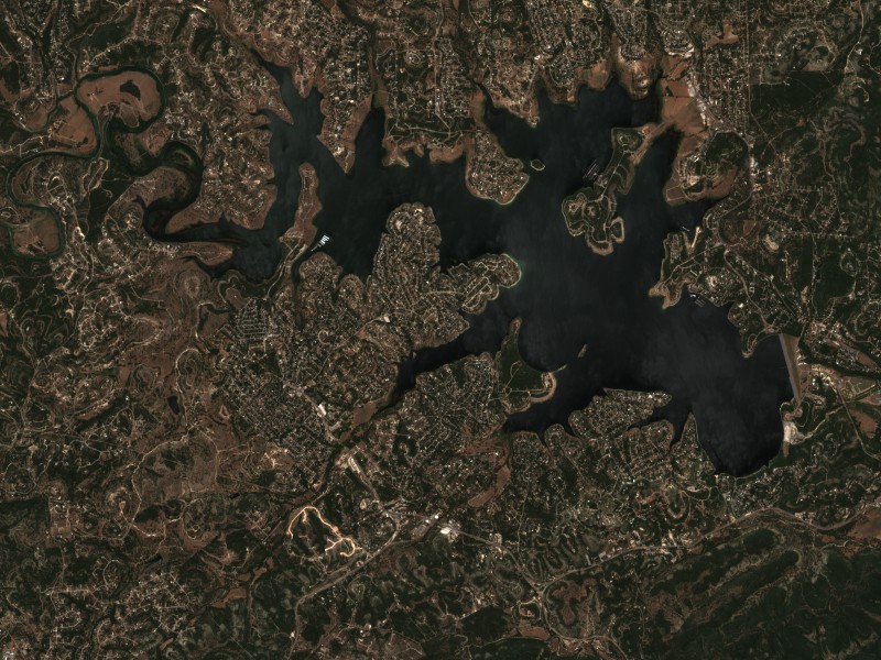
Satellite imagery and indices processed via Copernicus Data Space Ecosystem (CDSE) / Sentinel Hub API. Data reflects actual surface conditions at the time of orbital passage.
Derived from Band 4 red reflectance across open water pixels. Low reflectance indicates minimal suspended silt and high underwater visibility for angling and navigation.
Normalized Difference Chlorophyll Index (NDCI: 0.029) measures phytoplankton concentration using Red-Edge (B05) and Red (B04) bands to detect early bloom development before surface scums appear.
Normalized Difference Water Index (NDWI) contrasts Green and Near-Infrared spectra to map shallow shoals, sandbars, and exposed islands (like Sometimes Island on Travis or Wood Island on Texoma).
Recommended Gear for Current Conditions
Algorithmically matched to today's water temperature (76°F), lake elevation, and weather forecast.
Bassdash UPF 50+ Performance UV Sun Protection Fishing Hoodie
Ultra-breathable moisture-wicking UV shield designed to prevent all-day open water sunburn and heat fatigue without overheating.
Taylor Made Products Low Freeboard Boat Fender & Dock Bumper
Lake is 18.1 ft low; exposed slips and low shorelines risk heavy hull scrapes from wake surges.
SereneLife 10'6" Inflatable Stand Up Paddleboard (Complete Kit)
Calm winds (5 mph) offer pristine mirror-calm coves for touring, paddleboard fitness, and shoreline exploration.
Garmin Striker 4 Fishfinder with CHIRP Sonar & Dual-Beam Transducer
High-frequency CHIRP sonar pinpoints submerged humps, river channel dropoffs, bait balls, and suspended gamefish with crisp target separation.
Commercial Marinas & Featured Partners on Canyon Lake
Verified marine operators, boat slip facilities, and licensed guide services.
Featured Fishing Guides on Canyon Lake
Are you a licensed fishing guide or charter captain on Canyon Lake? Feature your guide service at the top of our daily solunar fishing forecast and water report.
Marinas & Boat Rentals on Canyon Lake
Connect directly with lake homeowners and visiting boaters searching for pontoon rentals, boat slips, dry storage, and marine service.
Living on Canyon Lake
Considering buying a lake cabin, dockable waterfront home, or retirement property on Canyon Lake? Water levels, dock stability, and flood pool buffers are critical factors in waterfront valuation.
USACE Fort Worth District and Guadalupe-Blanco River Authority (GBRA). Regulates discharge down the world-famous Guadalupe River tubing chute. Low water conditions can impact boat ramp usability.
Canyon Lake, TX
Hill country lake community with scenic winding roads, live music venues, and marinas.
New Braunfels, TX
Historic German heritage city with Schlitterbahn, Gruene Hall, and river tube outfitters.