
Lake Ray Roberts
U.S. Army Corps of Engineers, Fort Worth District • Impounded 1987 • 25,600 surface acres
Lake Ray Roberts
Lake-specific guide · Agency-sourced
Ray Roberts Lake: Elm Fork arms, state park access and fishing habitat
An Elm Fork reservoir with several ways in
Ray Roberts Lake occupies the Elm Fork of the Trinity River north of Denton. The dam is in Denton County, while the reservoir reaches Cooke and Grayson counties. Texas Parks and Wildlife Department (TPWD) gives 1987 as its impoundment year and identifies the U.S. Army Corps of Engineers as the controlling authority. The same lake profile lists a 632.5-foot conservation-pool elevation. That number provides a reference for the dated gauge reading on this page; it does not describe whether a particular ramp is open or safe to use.
The lake has more than one kind of shoreline. TPWD identifies standing timber mainly in the upper reaches of its two major arms, riprap by the dam and bridges, stream channels, flooded points, and patches of aquatic vegetation. The 2023 fisheries survey describes rocky shoreline, dead trees and vegetation at its sampling sites. Those observations are useful for understanding why a plan made for the open main pool may not fit an upper arm.
Fishing across the arms
The TPWD lake profile identifies largemouth bass, white bass, blue and channel catfish, crappie and sunfish. It describes a spring white-bass run up tributaries and summer schooling around the main pool, while the standing timber and other submerged structure provide different settings for bass and crappie. These are recurring habitat and seasonal patterns, not a report of current fishing success. The lake’s latest agency report, when available, belongs alongside its observed level and the day’s weather forecast.
The survey notes bank access at the two state park units and several bridge crossings. A visitor who does not launch a boat can start with those public access choices, then check the relevant park information before traveling. For fishing limits and license requirements, use TPWD’s current links rather than a number copied into an evergreen guide.
Choosing a launch
TPWD’s access directory lists the Isle du Bois and Johnson Branch state park units, Jordan Park, Sanger Park, Pond Creek and other launches. They serve different shorelines; the two state park units are not interchangeable entrances to one parking lot. The agency’s August 2024 ramp survey recorded separate coordinates for Johnson Branch, Isle du Bois and Jordan Park. Those survey positions place the ramps on the map but cannot establish today’s operating status.
The directory lists water elevations at which individual ramps are subject to closure. These differ by ramp and can change with management decisions. Check the current TPWD access listing and park or marina operator before towing a boat. A lake-wide gauge reading alone cannot prove that a boarding pier, lane or approach is usable.
Shoreline care and trip planning
TPWD posts a zebra-mussel advisory on both its fishing and access pages. Follow the agency’s current boat-cleaning directions when moving between waters. The 2024 survey also reports that high lake levels had caused temporary ramp closures in prior years, showing why access checks matter at either end of the level range. For a practical trip plan, identify a specific entrance, read its current notice, compare the dated level with the lake’s reference pool, and keep the forecast separate from observed conditions.
Sources reviewed October 2026. Check current levels and operator notices before visiting.
Lake Ray Roberts Boat Ramps, Campgrounds & Marinas
Each site below links to the official listing it came from. Ramp closures depend on each ramp's design and the lake level, and most operators don't publish them in real time, so confirm with U.S. Army Corps of Engineers, Fort Worth District before you launch.
Boat Ramps & Launches
Public launches, lane counts, fees, and federal pass info. Confirm ramp status with the operator before launching.🚤 Isle du Bois
Check StatusCoordinates and public access recorded in TPWD fisheries survey; verify current ramp conditions with operator.
🚤 Johnson Branch
Check StatusCoordinates and public access recorded in TPWD fisheries survey; verify current ramp conditions with operator.
🚤 Jordan Park
Check StatusCoordinates and public access recorded in TPWD fisheries survey; verify current ramp conditions with operator.
Parks & Day-Use Areas
Listed by Recreation.gov. Facilities vary; check each park's page for boat launch access.🌳 Isle Dubois State Park
🌳 Johnson Branch State Park
Fishing Lake Ray Roberts
Lake Ray Roberts Fishing Report
Waning Crescent (20% illuminated); strongest solunar period: Moon Overhead 7:42 AM–9:42 AM CST; lake at 630.62 ft, 1.9 ft below normal pool, steady over 24 hours.
Fishing & Boating Rules
Official SourcesLimits, licenses, and boating requirements change often. Check the current official rules before fishing or boating on Lake Ray Roberts:
Report Conditions on Lake Ray Roberts
Seen a hazard, a ramp closure, or changing water clarity? Reports go to LakeWatchers for review.
Were you on the water today?
Tell us about water clarity, ramp conditions, or hazards. We review reports and use them to correct the information on this page.
Latest Satellite Image of Lake Ray Roberts
A true-colour image from the most recent low-cloud Sentinel-2 pass over the lake. It shows the lake as it looked on the capture date, not today.
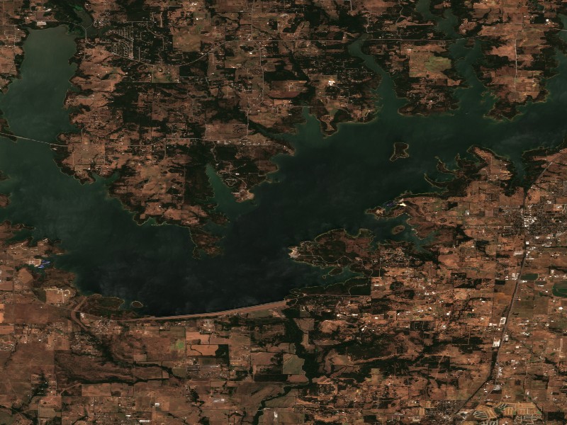
Contains modified Copernicus Sentinel data 2026, processed via the Copernicus Data Space Ecosystem.
Commercial Marinas & Featured Partners on Lake Ray Roberts
Marinas from official listings, plus open spots for local guides and rental operators.
Featured Fishing Guides on Lake Ray Roberts
Are you a licensed fishing guide or charter captain on Lake Ray Roberts? Feature your guide service on the Lake Ray Roberts page next to its fishing section.
Marinas & Boat Rentals on Lake Ray Roberts
Connect directly with lake homeowners and visiting boaters searching for pontoon rentals, boat slips, dry storage, and marine service.
Living Near Lake Ray Roberts
Shoreline and docks. Shoreline use on Lake Ray Roberts is managed by U.S. Army Corps of Engineers, Fort Worth District. Whether private docks are allowed, and where, depends on that operator's shoreline rules. Before making an offer on waterfront property, confirm with the operator whether a dock permit exists and whether it transfers to a new owner.
Flood pool and easements. The normal pool is 632.50 ft MSL and the flood pool reaches 640.50 ft MSL, a 8 ft difference. Property near the water may carry flowage easements that limit building below a set elevation. Check the deed, a survey and the operator's rules before buying.
Nearby towns. Pilot Point, TX, Sanger, TX, Denton, TX. Property taxes, utilities, HOA covenants and short-term rental rules vary between towns and counties.
Living on Lake Ray Roberts
Considering a lake cabin, waterfront home, or retirement property on Lake Ray Roberts? Water levels, dock permits, and flood pool limits all affect waterfront property, so review them before you buy.
Pilot Point, TX
Sanger, TX
Denton, TX
Aubrey, TX
Nearby Lakes
Lake Texoma
OK/TXWeekend trip planning: Lakes Near Dallas-Fort Worth, TX · Lakes Near Oklahoma City, OK