
Sam Rayburn Reservoir
U.S. Army Corps of Engineers, Fort Worth District • Impounded 1965 • 114,500 surface acres
Sam Rayburn Reservoir
Lake-specific guide · Agency-sourced
Sam Rayburn Reservoir: Angelina River habitat and access across the lake
The Angelina River reservoir
Sam Rayburn Reservoir lies on the Angelina River, with its dam in Jasper County north of Jasper. Texas Parks and Wildlife Department (TPWD) lists 1965 as its impoundment year, 114,500 surface acres and the U.S. Army Corps of Engineers as controlling authority. TPWD gives a 164.4-foot conservation-pool elevation. The observed water level on this page has its own timestamp; a pool comparison cannot establish whether a launch on a distant arm is usable.
The lake changes character from end to end. TPWD describes relatively clearer lower water and upper reaches with more off-color water. Submerged vegetation, standing timber and flooded terrestrial vegetation form much of the habitat. In the lower reservoir, the agency points to vegetation edges, flats, humps and creek channels. Farther up, timber, brush, laydowns and channels become more prominent in its description. These are long-running habitat patterns, not a live map of vegetation on today’s waterline.
Fishing across different cover
The TPWD lake profile names largemouth bass, crappie, catfish and white bass among the predominant species. It also notes bluegill and redear sunfish. The agency describes seasonal and annual water-level changes that alter flooded cover and vegetation. An angler’s choice between a lower-lake vegetation edge and an upper-lake timber area therefore depends on the observed level, local conditions and the current agency report, rather than on a fixed claim that one area always fishes best.
TPWD links a habitat structure viewer for mapped fish attractors. It also flags a consumption advisory on the lake profile; follow that link for the current advisory and species details before keeping fish. This guide does not repeat changing limits, advisory boundaries or seasonal conditions as permanent facts.
A large, distributed access network
The TPWD access overview describes 22 maintained access areas, with ramps at those areas, and warns that some can be unusable when levels are low. Its detailed directory places Twin Dikes Park at the east end of the dam, Sandy Creek Park on the western side, and Hanks Creek Park farther north. These are distinct starting points for different parts of the reservoir, not interchangeable entries to one shoreline.
TPWD’s 2018 fisheries survey records public-ramp coordinates for those three sites. The map locations are drawn from that dated survey; its ramp condition table should not be read as a current status report. Before towing a boat, use the operator information in TPWD’s directory and check current notices for the chosen park. An agency listing of a ramp establishes that it is an access site, not that its lane is available at today’s elevation.
Planning at the scale of this lake
Sam Rayburn’s multiple arms and access operators make a site-specific plan more useful than a lake-wide launch assumption. The access directory identifies Corps, Forest Service, county and concession-managed areas. The agency also notes that camping is available at some, not all, access areas. Choose the part of the reservoir first, find an appropriate listed site, confirm current conditions with its operator, and then use the dated level and forecast to refine the trip.
Sources reviewed October 2026. Check current levels and operator notices before visiting.
Sam Rayburn Reservoir Boat Ramps, Campgrounds & Marinas
Each site below links to the official listing it came from. Ramp closures depend on each ramp's design and the lake level, and most operators don't publish them in real time, so confirm with U.S. Army Corps of Engineers, Fort Worth District before you launch.
Boat Ramps & Launches
Public launches, lane counts, fees, and federal pass info. Confirm ramp status with the operator before launching.🚤 Hanks Creek Park
Check StatusCoordinates and public access recorded in TPWD fisheries survey; verify current ramp conditions with operator.
🚤 Sandy Creek Park
Check StatusCoordinates and public access recorded in TPWD fisheries survey; verify current ramp conditions with operator.
🚤 Twin Dikes Park
Check StatusCoordinates and public access recorded in TPWD fisheries survey; verify current ramp conditions with operator.
Fishing Sam Rayburn Reservoir
Sam Rayburn Reservoir Fishing Report
Waning Crescent (20% illuminated); strongest solunar period: Moon Overhead 7:29 AM–9:29 AM CST; lake at 152.81 ft, 11.6 ft below normal pool, steady over 24 hours.
Fishing & Boating Rules
Official SourcesLimits, licenses, and boating requirements change often. Check the current official rules before fishing or boating on Sam Rayburn Reservoir:
Report Conditions on Sam Rayburn Reservoir
Seen a hazard, a ramp closure, or changing water clarity? Reports go to LakeWatchers for review.
Were you on the water today?
Tell us about water clarity, ramp conditions, or hazards. We review reports and use them to correct the information on this page.
Latest Satellite Image of Sam Rayburn Reservoir
A true-colour image from the most recent low-cloud Sentinel-2 pass over the lake. It shows the lake as it looked on the capture date, not today.
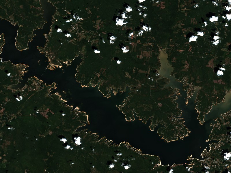
Contains modified Copernicus Sentinel data 2026, processed via the Copernicus Data Space Ecosystem.
Commercial Marinas & Featured Partners on Sam Rayburn Reservoir
Marinas from official listings, plus open spots for local guides and rental operators.
Featured Fishing Guides on Sam Rayburn Reservoir
Are you a licensed fishing guide or charter captain on Sam Rayburn Reservoir? Feature your guide service on the Sam Rayburn Reservoir page next to its fishing section.
Marinas & Boat Rentals on Sam Rayburn Reservoir
Connect directly with lake homeowners and visiting boaters searching for pontoon rentals, boat slips, dry storage, and marine service.
Living Near Sam Rayburn Reservoir
Shoreline and docks. Shoreline use on Sam Rayburn Reservoir is managed by U.S. Army Corps of Engineers, Fort Worth District. Whether private docks are allowed, and where, depends on that operator's shoreline rules. Before making an offer on waterfront property, confirm with the operator whether a dock permit exists and whether it transfers to a new owner.
Flood pool and easements. The normal pool is 164.40 ft MSL and the flood pool reaches 173.00 ft MSL, a 8.6 ft difference. Property near the water may carry flowage easements that limit building below a set elevation. Check the deed, a survey and the operator's rules before buying.
Nearby towns. Jasper, TX, Lufkin, TX, Broaddus, TX, Zavalla, TX. Property taxes, utilities, HOA covenants and short-term rental rules vary between towns and counties.
Living on Sam Rayburn Reservoir
Considering a lake cabin, waterfront home, or retirement property on Sam Rayburn Reservoir? Water levels, dock permits, and flood pool limits all affect waterfront property, so review them before you buy.
Jasper, TX
Zavalla, TX
Nearby Lakes
Weekend trip planning: Lakes Near Dallas-Fort Worth, TX