Lake Guntersville
Tennessee Valley Authority (TVA) • Built 1939 • 69,100 surface acres • 890 miles shoreline
Lake Guntersville
Great Day on the Water
Level is right at normal conservation pool (-0.8 ft), water temp is a comfortable 80°f, light winds around 0 mph, no active algae or safety advisories.
What to Know About Lake Guntersville
Consistently rated the #1 largemouth bass lake in the southern United States by Bassmaster. Extensive hydrilla and milfoil grass beds produce extraordinary numbers of 5 to 10-pound bass. Lake Guntersville State Park lodge sits atop a high Appalachian bluff.
Boat Ramps & Launches
Public concrete launches, usable lake elevations, and federal pass info🚤 Lake Guntersville Main Public Ramp
Usable (Level OK)Paved deep-water concrete ramp with courtesy dock and lit parking.
🚤 Lake Guntersville Resort Marina
Usable (Level OK)Full service marina with marine mechanics, fuel dock, and rental fleet.
Full-Service Marinas
Fuel docks, wet slips, ship stores, and boat rentals⚓ Lake Guntersville Resort Marina
Full service marina with marine mechanics, fuel dock, and rental fleet.
Today's Fishing Outlook
Favorable feeding forecast today with the First Quarter (56% illuminated). Surface water is 80°F with a steady pool (-0.01' in 24h). Fish will feed aggressively along windblown points and main-lake humps during the primary major window.
Fishing Regulations & Species
State Wildlife AgencyLicense Info: Alabama DCNR freshwater fishing license.
Regulations Summary: Top stop on the Bassmaster Elite Series.
View Official Wildlife Department Regulations →Lake Rules & Boating Safety
Commercial barge navigation channel active; obey river mile marker buoys.
Recent Community Reports
Real-time water clarity, hazards, and ramp wait times shared by boaters and anglers.
No community reports submitted in the last 24 hours for Lake Guntersville
Were you on the water today? Share water clarity, ramp conditions, or hazards to help fellow lake visitors.
Spaceborne Satellite Observation & Water Clarity
Fresh multi-spectral overhead Earth observation from the European Space Agency (ESA) Sentinel-2 constellation (10m spatial resolution).
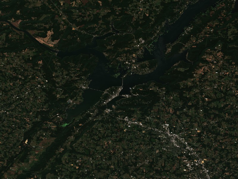
Satellite imagery and indices processed via Copernicus Data Space Ecosystem (CDSE) / Sentinel Hub API. Data reflects actual surface conditions at the time of orbital passage.
Derived from Band 4 red reflectance across open water pixels. Low reflectance indicates minimal suspended silt and high underwater visibility for angling and navigation.
Normalized Difference Chlorophyll Index (NDCI: 0.057) measures phytoplankton concentration using Red-Edge (B05) and Red (B04) bands to detect early bloom development before surface scums appear.
Normalized Difference Water Index (NDWI) contrasts Green and Near-Infrared spectra to map shallow shoals, sandbars, and exposed islands (like Sometimes Island on Travis or Wood Island on Texoma).
Recommended Gear for Current Conditions
Algorithmically matched to today's water temperature (80°F), lake elevation, and weather forecast.
Airhead Super Mable 3-Rider Towable Tube with Dual Tow Points
Warm 80°F surface water offers perfect conditions for wake tubing, chariot riding, and family towing action.
Onyx A/M-24 Deluxe Automatic/Manual Inflatable Life Jacket (USCG)
Lightweight, comfortable low-profile design that automatically inflates upon immersion while allowing full arm mobility for driving and casting.
SereneLife 10'6" Inflatable Stand Up Paddleboard (Complete Kit)
Calm winds (0 mph) offer pristine mirror-calm coves for touring, paddleboard fitness, and shoreline exploration.
Garmin Striker 4 Fishfinder with CHIRP Sonar & Dual-Beam Transducer
High-frequency CHIRP sonar pinpoints submerged humps, river channel dropoffs, bait balls, and suspended gamefish with crisp target separation.
Commercial Marinas & Featured Partners on Lake Guntersville
Verified marine operators, boat slip facilities, and licensed guide services.
⚓ Lake Guntersville Resort Marina
Full service marina with marine mechanics, fuel dock, and rental fleet.
Charter Guide or Boat Rental on Lake Guntersville?
Reach thousands of visiting boaters and anglers checking live water levels, surface temperatures, and ramp conditions before heading to Lake Guntersville.
Living on Lake Guntersville
Considering buying a lake cabin, dockable waterfront home, or retirement property on Lake Guntersville? Water levels, dock stability, and flood pool buffers are critical factors in waterfront valuation.
TVA operates Guntersville with consistent year-round lake levels within a narrow 2-foot band.
Guntersville, AL
Stunning town built on an island-like peninsula surrounded by water, Lake Guntersville State Park.
Scottsboro, AL
Famous home of the Unclaimed Baggage Center, historic courthouse square, and northern lake arms.
Albertville, AL
Thriving Sand Mountain community offering shopping, dining, and southern lake proximity.
Langston, AL
Peaceful eastern shore community with sprawling shoreline lots and mountain backdrops.