
Greers Ferry Lake
USACE Little Rock District • Built 1962 • 31,500 surface acres • 340 miles shoreline
Greers Ferry Lake
Great Day on the Water
Level is right at normal conservation pool (-0.7 ft), water temp is a comfortable 75°f, light winds around 0 mph, no active algae or safety advisories.
What to Know About Greers Ferry Lake
Dedicated by President John F. Kennedy in October 1963 in one of his final public appearances. The Little Red River tailrace downstream produced a former 40-pound world record brown trout.
Boat Ramps & Launches
Public concrete launches, usable lake elevations, and federal pass info🚤 Cherokee
Usable (Level OK)Public boat launch facility providing direct water access with vehicle and boat trailer parking.
🚤 Cove Creek
Usable (Level OK)Public boat launch facility providing direct water access with vehicle and boat trailer parking.
🚤 Dam Site Marina
Usable (Level OK)Full-service marina providing vessel mooring, slip rentals, fuel dock, and visitor services.
🚤 Greers Ferry National Fish Hatchery
Usable (Level OK)Greers Ferry National Fish Hatchery, established in 1965, is nestled along the beautiful tailwaters of the Little Red River below Greers Ferry Dam. Nearby you'll find excellent opportunities for camping and world class t...
🚤 Mill Creek Park
Usable (Level OK)Public recreation park offering lakefront shoreline access, picnic areas, and boat launch facilities.
🚤 Van Buren Park
Usable (Level OK)Public recreation park offering lakefront shoreline access, picnic areas, and boat launch facilities.
🚤 William C. Garner Visitor Center
Usable (Level OK)Official visitor center offering historical exhibits, public facilities, and regional park information.
Campgrounds & RV Parks
Official federal, Corps of Engineers & state park campsites⛺ Choctaw
$18 - $32 / nightChoctaw Park is located on the spacious Greers Ferry Lake nestled in the foothills of the Ozark Mountains. In the 19th century, a city named Higden flourished where the lake now rests. The city suffered from fre...
⛺ Dam Site Campground
$18 - $32 / nightWaterfront camping facility offering tent and RV campsites with scenic lake views and recreational access.
⛺ Dam Site(Greers Ferry)
$18 - $32 / nightDam Site Park is located at Greers Ferry Dam at the foot of Round Mountain in the beautiful Ozark Mountains of north-central Arkansas. The environment provides the ideal location for family camping, fishing, boa...
⛺ Devils Fork
$18 - $32 / nightDevils Fork Park is located on Greers Ferry Lake in the beautiful Ozark Mountains of north-central Arkansas. The environment provides the ideal location for family camping, fishing, boating and hiking. Recreatio...
⛺ Heber Springs
$18 - $32 / nightHeber Springs Park is located on Greers Ferry Lake in the beautiful Ozark Mountains of north-central Arkansas. The environment provides the ideal location for family camping, fishing, boating and hiking. Recreat...
⛺ Hill Creek
$18 - $32 / nightHill Creek Park is located on Greers Ferry Lake in the beautiful Ozark Mountains of north-central Arkansas. The environment provides the ideal location for family camping, fishing, boating and hiking. Recreation...
⛺ John F Kennedy
$18 - $32 / nightJohn F. Kennedy Park is located on the Little Red River just downstream of Greers Ferry Dam in the beautiful Ozark Mountains of north-central Arkansas. In his last major appearance before his death, President Jo...
⛺ Narrows (Ar)
$18 - $32 / nightNarrows Park is located on Greers Ferry Lake in the beautiful Ozark Mountains of north-central Arkansas. The environment provides the ideal location for family camping, fishing, boating and hiking. Recreation Gr...
⛺ Old Highway 25
$18 - $32 / nightOld Highway 25 Park is located on Greers Ferry Lake in the beautiful Ozark Mountains of north-central Arkansas. The environment provides the ideal location for family camping, fishing, boating and hiking. Recrea...
⛺ Shiloh
$18 - $32 / nightShiloh Park is located on Greers Ferry Lake in the beautiful Ozark Mountains of north-central Arkansas. The environment provides the ideal location for family camping, fishing, boating and hiking. Recreation Gre...
⛺ Sugar Loaf
$18 - $32 / nightSugar Loaf Park is located on Greers Ferry Lake in the beautiful Ozark Mountains of north-central Arkansas. The environment provides the ideal location for family camping, fishing, boating and hiking. Recreation...
Full-Service Marinas
Fuel docks, wet slips, ship stores, and boat rentals⚓ Dam Site Marina
Full-service marina providing vessel mooring, slip rentals, fuel dock, and visitor services.
Today's Fishing Outlook
Favorable feeding forecast today with the First Quarter (56% illuminated). Surface water is 75°F with a steady pool (-0.01' in 24h). Fish will feed aggressively along windblown points and main-lake humps during the primary major window.
Fishing Regulations & Species
State Wildlife AgencyLicense Info: AGFC license.
Regulations Summary: World-class fly fishing tailrace downstream.
View Official Wildlife Department Regulations →Lake Rules & Boating Safety
Sugar Loaf Mountain trail accessible only by boat; hiking allowed dawn to dusk.
Recent Community Reports
Real-time water clarity, hazards, and ramp wait times shared by boaters and anglers.
No community reports submitted in the last 24 hours for Greers Ferry Lake
Were you on the water today? Share water clarity, ramp conditions, or hazards to help fellow lake visitors.
Spaceborne Satellite Observation & Water Clarity
Fresh multi-spectral overhead Earth observation from the European Space Agency (ESA) Sentinel-2 constellation (10m spatial resolution).
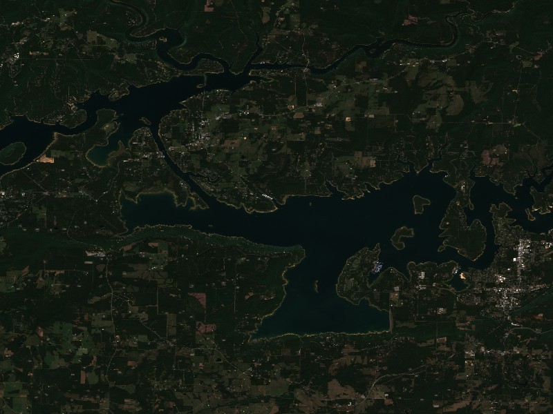
Satellite imagery and indices processed via Copernicus Data Space Ecosystem (CDSE) / Sentinel Hub API. Data reflects actual surface conditions at the time of orbital passage.
Derived from Band 4 red reflectance across open water pixels. Low reflectance indicates minimal suspended silt and high underwater visibility for angling and navigation.
Normalized Difference Chlorophyll Index (NDCI: -0.041) measures phytoplankton concentration using Red-Edge (B05) and Red (B04) bands to detect early bloom development before surface scums appear.
Normalized Difference Water Index (NDWI) contrasts Green and Near-Infrared spectra to map shallow shoals, sandbars, and exposed islands (like Sometimes Island on Travis or Wood Island on Texoma).
Recommended Gear for Current Conditions
Algorithmically matched to today's water temperature (75°F), lake elevation, and weather forecast.
Bassdash UPF 50+ Performance UV Sun Protection Fishing Hoodie
Ultra-breathable moisture-wicking UV shield designed to prevent all-day open water sunburn and heat fatigue without overheating.
Onyx A/M-24 Deluxe Automatic/Manual Inflatable Life Jacket (USCG)
Lightweight, comfortable low-profile design that automatically inflates upon immersion while allowing full arm mobility for driving and casting.
SereneLife 10'6" Inflatable Stand Up Paddleboard (Complete Kit)
Calm winds (0 mph) offer pristine mirror-calm coves for touring, paddleboard fitness, and shoreline exploration.
Garmin Striker 4 Fishfinder with CHIRP Sonar & Dual-Beam Transducer
High-frequency CHIRP sonar pinpoints submerged humps, river channel dropoffs, bait balls, and suspended gamefish with crisp target separation.
Commercial Marinas & Featured Partners on Greers Ferry Lake
Verified marine operators, boat slip facilities, and licensed guide services.
⚓ Dam Site Marina
Full-service marina facility providing vessel mooring, guest slip rentals, marine fuel dock, and lakefront boater amenities on Greers Ferry Lake.
Charter Guide or Boat Rental on Greers Ferry Lake?
Reach thousands of visiting boaters and anglers checking live water levels, surface temperatures, and ramp conditions before heading to Greers Ferry Lake.
Living on Greers Ferry Lake
Considering buying a lake cabin, dockable waterfront home, or retirement property on Greers Ferry Lake? Water levels, dock stability, and flood pool buffers are critical factors in waterfront valuation.
25-foot flood pool buffer in the Little Red River valley.
Heber Springs, AR
Lake gateway with historic courthouse square, Little Red River trout tailwaters, and Dam Site Park.
Fairfield Bay, AR
Resort community on the north shore featuring championship golf, tennis, and full-service marina.
Greers Ferry, AR
Scenic central lakeside enclave near Devils Fork recreation area and deep water coves.
Clinton, AR
Ozark mountain gateway providing shopping, dining, and scenic western lake access.