
Table Rock Lake
USACE Little Rock District • Built 1958 • 43,100 surface acres • 800 miles shoreline
Table Rock Lake
Great Day on the Water
Level is right at normal conservation pool (-0.8 ft), water temp is 72°f (crisp), light winds around 5 mph, no active algae or safety advisories.
What to Know About Table Rock Lake
One of the crown jewels of the Ozarks, directly adjacent to the entertainment hub of Branson. Table Rock State Park marina is top tier with catamaran sailing tours and clear deep water.
Boat Ramps & Launches
Public concrete launches, usable lake elevations, and federal pass info🚤 Dewey Short Visitor Center
Usable (Level OK)Official visitor center offering historical exhibits, public facilities, and regional park information.
🚤 Kimberling Park
Usable (Level OK)Public recreation park offering lakefront shoreline access, picnic areas, and boat launch facilities.
🚤 Table Rock State Park
Usable (Level OK)Public recreation park offering lakefront shoreline access, picnic areas, and boat launch facilities.
Campgrounds & RV Parks
Official federal, Corps of Engineers & state park campsites⛺ Aunts Creek
$18 - $32 / nightAunts Creek campground is located on the James River Arm of Table Rock Lake. With easy access to the highly productive waters of the James River Arm, fishermen and campers looking to fish, will find no shortage ...
⛺ Baxter
$18 - $32 / nightBaxter is a spacious and sunny campground that sits along the White River Arm of Table Rock Lake. The highly productive fishing waters of the White River Arm will appeal to anglers, while the Baxter full-service...
⛺ Beaver Creek (Mo)
$18 - $32 / nightEscape from the hustle and bustle of city-life at Beaver Creek, a small, quiet campground tucked between a forested area and the lower shores of Bull Shoals Lake. The lake, in the beautiful Ozark Mountains, attr...
⛺ Campbell Point
$18 - $32 / nightCampbell Point is a spacious and shady campground that sits along the White River Arm of Table Rock Lake. Plenty of soft, grassy areas are available for picnicking and running around, while a large sandy beach p...
⛺ Cape Fair
$18 - $32 / nightCape Fair is a spacious and shady campground that sits along the James River Arm of Table Rock Lake. Perfect for water and nature lovers alike, Cape Fair campground provides a scenic escape in the beautiful foot...
⛺ Cricket Creek
$18 - $32 / nightCricket Creek is a spacious and sunny campground located along the Long Creek Arm of Table Rock Lake in the Arkansas countryside. With panoramic views of the lake and the rocky bluffs, which rise above the water...
⛺ Indian Point
$18 - $32 / nightIndian Point is a green and spacious campground on the White River Arm of Table Rock Lake in the mountainous Missouri countryside. A wooded campground with plenty of shade and access to the lake is ideal for vis...
⛺ Mill Creek (Missouri)
$18 - $32 / nightMill Creek is a spacious and sunny campground on the White River Arm of Table Rock Lake in the Missouri countryside. Many campsites within this park are located adjacent to the waters edge, with the remaining ca...
⛺ Moonshine Beach Rec. Area
$18 - $32 / nightMoonshine Beach Recreation Area is a very popular sandy swimming beach along the shores of Table Rock Lake. Unlike the smaller swimming areas at the campgrounds surrounding Table Rock Lake, Moonshine beach is sp...
⛺ Old Highway 86
$18 - $32 / nightOld Highway 86 is a spacious and sunny campground that sits along the White River Arm of Table Rock Lake in the rolling Missouri countryside. Recreation Whether on water or land, Old Highway 86 Campground offers...
⛺ River Run Park
$18 - $32 / nightRiver Run Park is conveniently located just below Powersite Dam allowing quick lake access for fishing or recreational watersports. Recreation Hiking, birding, all types of water sports, and in-season hunting ar...
⛺ Shell Knob Rec Site Pavilion
$18 - $32 / nightShell Knob Recreation Site is situated along a bluff overlooking the White River arm of beautiful Table Rock Lake, in an unincorporated portion of Shell Knob. It is a great location to relax and enjoy being away...
⛺ Viola
$18 - $32 / nightViola sits along the Kings River Arm of Table Rock Lake in the Missouri countryside. Boaters and water sports enthusiasts are particularly drawn to Viola for its easy access to the clear blue waters of Table Roc...
Today's Fishing Outlook
Favorable feeding forecast today with the First Quarter (56% illuminated). Surface water is 72°F with a steady pool (-0.01' in 24h). Fish will feed aggressively along windblown points and main-lake humps during the primary major window.
Fishing Regulations & Species
State Wildlife AgencyLicense Info: MDC Missouri fishing license required.
Regulations Summary: 15-inch minimum length on black bass.
View Official Wildlife Department Regulations →Lake Rules & Boating Safety
All standard USACE and Missouri Water Patrol boating regulations apply.
Recent Community Reports
Real-time water clarity, hazards, and ramp wait times shared by boaters and anglers.
No community reports submitted in the last 24 hours for Table Rock Lake
Were you on the water today? Share water clarity, ramp conditions, or hazards to help fellow lake visitors.
Spaceborne Satellite Observation & Water Clarity
Fresh multi-spectral overhead Earth observation from the European Space Agency (ESA) Sentinel-2 constellation (10m spatial resolution).
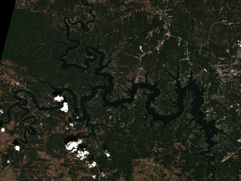
Satellite imagery and indices processed via Copernicus Data Space Ecosystem (CDSE) / Sentinel Hub API. Data reflects actual surface conditions at the time of orbital passage.
Derived from Band 4 red reflectance across open water pixels. Low reflectance indicates minimal suspended silt and high underwater visibility for angling and navigation.
Normalized Difference Chlorophyll Index (NDCI: -0.017) measures phytoplankton concentration using Red-Edge (B05) and Red (B04) bands to detect early bloom development before surface scums appear.
Normalized Difference Water Index (NDWI) contrasts Green and Near-Infrared spectra to map shallow shoals, sandbars, and exposed islands (like Sometimes Island on Travis or Wood Island on Texoma).
Recommended Gear for Current Conditions
Algorithmically matched to today's water temperature (72°F), lake elevation, and weather forecast.
Bassdash UPF 50+ Performance UV Sun Protection Fishing Hoodie
Ultra-breathable moisture-wicking UV shield designed to prevent all-day open water sunburn and heat fatigue without overheating.
Onyx A/M-24 Deluxe Automatic/Manual Inflatable Life Jacket (USCG)
Lightweight, comfortable low-profile design that automatically inflates upon immersion while allowing full arm mobility for driving and casting.
SereneLife 10'6" Inflatable Stand Up Paddleboard (Complete Kit)
Calm winds (5 mph) offer pristine mirror-calm coves for touring, paddleboard fitness, and shoreline exploration.
Garmin Striker 4 Fishfinder with CHIRP Sonar & Dual-Beam Transducer
High-frequency CHIRP sonar pinpoints submerged humps, river channel dropoffs, bait balls, and suspended gamefish with crisp target separation.
Commercial Marinas & Featured Partners on Table Rock Lake
Verified marine operators, boat slip facilities, and licensed guide services.
Featured Fishing Guides on Table Rock Lake
Are you a licensed fishing guide or charter captain on Table Rock Lake? Feature your guide service at the top of our daily solunar fishing forecast and water report.
Marinas & Boat Rentals on Table Rock Lake
Connect directly with lake homeowners and visiting boaters searching for pontoon rentals, boat slips, dry storage, and marine service.
Living on Table Rock Lake
Considering buying a lake cabin, dockable waterfront home, or retirement property on Table Rock Lake? Water levels, dock stability, and flood pool buffers are critical factors in waterfront valuation.
USACE controls releases into Lake Taneycomo downstream.
Branson, MO
Live entertainment and theater capital, Silver Dollar City, Branson Landing, and Table Rock State Park.
Kimberling City, MO
Central hub located at the iconic Table Rock bridge, offering deep-water marinas and lakeview homes.
Shell Knob, MO
Quiet western lake sanctuary famous for crystal-clear waters and peaceful residential coves.
Hollister, MO
English Tudor-style village adjacent to Table Rock Dam, premier golf resorts, and marina slips.