
Lake Tenkiller
U.S. Army Corps of Engineers, Tulsa District • Dam completed 1952 • 12,900 surface acres • 170 miles of shoreline
Lake-specific guide · Agency-sourced
Lake Tenkiller: a deep Ozark lake, clear-water diving and the trout river below
One river, one dam, a lot of fluctuation
Lake Tenkiller sits on the Illinois River in eastern Oklahoma, about ten miles south of Tahlequah. The Oklahoma Department of Wildlife Conservation dates the impoundment to 1952 and calls Tenkiller the only controlled impoundment on the Illinois River. The same page warns that the lake “can experience prolonged drastic lake level fluctuations.” That is the most useful fact a first-time visitor can carry. The U.S. Army Corps of Engineers operates the dam, and a cove that was deep enough in spring can be a mudflat by late summer, or the reverse after a wet season upstream.
Use the current reading on this page as a starting point, then look at the specific ramp or swim area you intend to use. A lake-wide elevation cannot tell you whether a particular launch still reaches the water.
Bluffs, depth and unusually clear water
ODWC describes Tenkiller as “a deep, clear lake dominated by a shoreline with rocky bluffs and outcroppings,” set in the Ozark highlands. Clarity is the reason Tenkiller has a reputation that most Oklahoma reservoirs do not: diving. Oklahoma’s state tourism department calls the lake one of the best places in the state for scuba. It describes a dive park at Tenkiller State Park with a sunken airplane fuselage, a school bus, a helicopter and two boats, and notes that divers in some parts of the lake can see remains of homesteads from before the lake was filled.
Visibility is not a fixed number. It changes with runoff, season and algae, so treat any published range as a description rather than a promise. Divers should also remember that a reservoir with boat traffic and changing levels needs a dive flag, a buddy and a check of current conditions with one of the local dive shops before entering the water.
The cold river below the dam
Depth matters below the dam as well as on the lake. ODWC explains that Tenkiller’s depth “provides cool water for the popular year-round trout fishery in the tailwaters.” The department’s trout area information defines that fishery as a 7.75-mile stretch of the Illinois River from Tenkiller Ferry Dam to the U.S. 64 bridge near Gore. It lists several public access points. A pool off the river immediately below the dam allows trout fishing even during high power generation, and the River Road Public Access Area lies about six miles downstream. The Simp and Helen Watts Management Unit is walk-in only, with sections restricted to artificial flies and lures and barbless hooks.
The lower river carries its own trout limits, and they differ by section. Read the current rules on that ODWC page before you keep a fish rather than relying on what someone remembers from last season. Water released for generation can also raise the river quickly, so wading anglers should stay alert to rising water and a strengthening current.
On the lake: species and special rules
ODWC’s Tenkiller page lists largemouth, smallmouth and spotted bass, black and white crappie, white bass, blue, flathead and channel catfish, walleye and several sunfish. That variety means the lake rewards anglers who decide on a target species first. Tenkiller also has area-specific crappie and method rules for the water downstream from the Horseshoe Bend boat ramp to the dam. Check that section of the same page before fishing that stretch.
Picking a base
ODWC notes that the Corps and Oklahoma State Parks both run campgrounds around the lake, and that private resorts in the Burnt Cabin, Caney Creek and Tenkiller State Park areas operate fishing dock concessions. Tenkiller State Park is the most developed choice. It has several campgrounds ranging from primitive to full hookup, cabins, a paved multi-use trail and Pine Cove Marina. Its Fisherman’s Point area combines a swim beach, the dive park and a boat ramp.
Pick the base by activity. Divers and swimmers will want Fisherman’s Point, trout anglers are better served near the dam and the river accesses, and a quieter campsite may be up-lake. Then confirm that the facility you chose is open at the current elevation.
Sources reviewed October 2026. Check current levels and operator notices before visiting.
Lake Tenkiller Boat Ramps, Campgrounds & Marinas
Each site below links to the official listing it came from. Ramp closures depend on each ramp's design and the lake level, and most operators don't publish them in real time, so confirm with U.S. Army Corps of Engineers, Tulsa District before you launch.
Boat Ramps & Launches
Public launches, lane counts, fees, and federal pass info. Confirm ramp status with the operator before launching.🚤 Carters Landing Boat Ramp
Check Status🚤 Chicken Creek Boat Ramp
Check Status🚤 Chicken Creek South Boat Ramp
Check Status🚤 Cookson Bend Boat Ramp
Check Status🚤 Elk Creek Landing Boat Ramp
Check Status🚤 Highway 10 Landing Boat Ramp
Check Status🚤 Pettit Bay Boat Ramp
Check Status🚤 Sizemore Landing Boat Ramp
Check Status🚤 Snake Creek Boat Ramp
Check StatusCampgrounds & RV Parks
Campgrounds listed by Recreation.gov and official park sources⛺ Chicken Creek
Check with operatorHead to Chicken Creek Campground for tons of fun on Tenkiller Ferry Lake. As one of the most popular campgrounds on the lake, Chicken Creek boasts modern facilities, impressive vistas, convenient access to boati...
⛺ Cookson Bend
Check with operatorCookson Bend Campground is a popular area that lies on Tenkiller Ferry Lake, among the Cookson Hills of the Ozark Mountains. Visitors here delight in breathtaking views of 200-foot limestone bluffs rising from t...
⛺ Elk Creek Landing
Check with operatorElk Creek Landing Park is a nice, quiet, enjoyable campground on Tenkiller Ferry Lake. It has modern facilities and handy access to the lake. The region features breathtaking views of 200-foot limestone bluffs r...
⛺ Pettit Bay
Check with operatorPettit Bay Campground on Tenkiller Ferry Lake is a recreational paradise for visitors looking for a well-kept waterfront facility, which offers convenient access for boating, swimming and wildlife viewing. It is...
⛺ Snake Creek
Check with operatorSnake Creek Park is one of the most popular campgrounds on Tenkiller Ferry Lake. With modern facilities, convenient access to boating, and plenty of opportunities to view wildlife, it's no wonder campers come he...
⛺ Strayhorn Landing
Check with operatorStrayhorn Landing, located on a peninsula on Tenkilller Ferry Lake, is an excellent place to relax and have fun on Tenkiller Ferry Lake. With modern facilities, a panoramic view of the lake, convenient access to...
Marinas
Marinas on the lake. Contact each marina for services and rates.⚓ Cookson Bend Marina
⚓ Elk Creek Marina
Parks & Day-Use Areas
Listed by Recreation.gov. Facilities vary; check each park's page for boat launch access.🌳 Barnacle Bill'S
🌳 Burnt Cabin
🌳 Carters Landing
🌳 Cherokee Landing State Park
🌳 Sixshooter
🌳 Sizemore Landing
🌳 Tenkiller State Park
Fishing Lake Tenkiller
Lake Tenkiller Fishing Report
Waning Crescent (20% illuminated); strongest solunar period: Moon Overhead 7:33 AM–9:33 AM CST; lake at 624.86 ft, 7.1 ft below normal pool, up 0.07 ft in 24 hours.
Official Fishing Reports
Fishing & Boating Rules
Official SourcesLimits, licenses, and boating requirements change often. Check the current official rules before fishing or boating on Lake Tenkiller:
Report Conditions on Lake Tenkiller
Seen a hazard, a ramp closure, or changing water clarity? Reports go to LakeWatchers for review.
Were you on the water today?
Tell us about water clarity, ramp conditions, or hazards. We review reports and use them to correct the information on this page.
Latest Satellite Image of Lake Tenkiller
A true-colour image from the most recent low-cloud Sentinel-2 pass over the lake. It shows the lake as it looked on the capture date, not today.
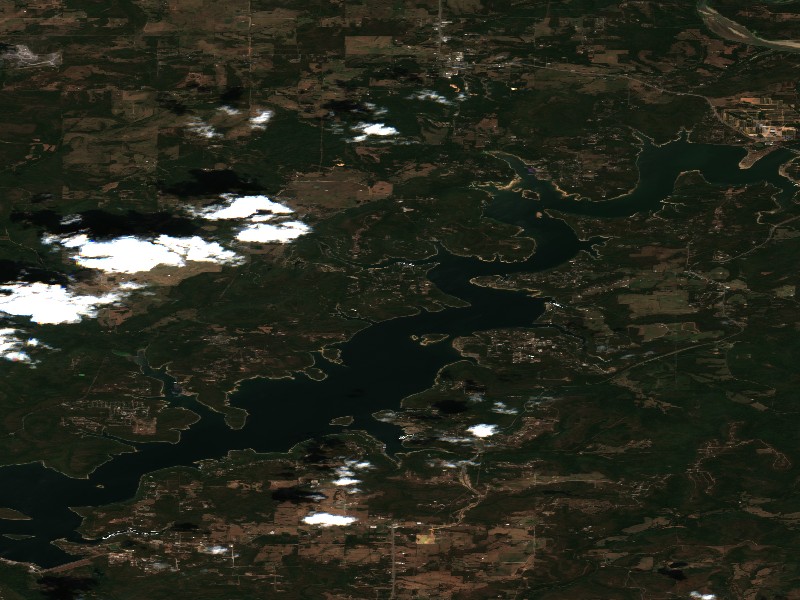
Contains modified Copernicus Sentinel data 2026, processed via the Copernicus Data Space Ecosystem.
Commercial Marinas & Featured Partners on Lake Tenkiller
Marinas from official listings, plus open spots for local guides and rental operators.
⚓ Cookson Bend Marina
⚓ Elk Creek Marina
Charter Guide or Boat Rental on Lake Tenkiller?
Reach boaters and anglers checking water levels and boat ramp listings before heading to Lake Tenkiller.
Living Near Lake Tenkiller
Shoreline and docks. Shoreline use on Lake Tenkiller is managed by U.S. Army Corps of Engineers, Tulsa District. Whether private docks are allowed, and where, depends on that operator's shoreline rules. Before making an offer on waterfront property, confirm with the operator whether a dock permit exists and whether it transfers to a new owner.
Flood pool and easements. The normal pool is 632.00 ft MSL and the flood pool reaches 667.00 ft MSL, a 35 ft difference. Property near the water may carry flowage easements that limit building below a set elevation. Check the deed, a survey and the operator's rules before buying.
Nearby towns. Gore, OK, Tahlequah, OK, Vian, OK. Property taxes, utilities, HOA covenants and short-term rental rules vary between towns and counties.
Living on Lake Tenkiller
Considering a lake cabin, waterfront home, or retirement property on Lake Tenkiller? Water levels, dock permits, and flood pool limits all affect waterfront property, so review them before you buy.
Gore, OK
Tahlequah, OK
Vian, OK
Cookson, OK
Nearby Lakes
Weekend trip planning: Lakes Near Tulsa, OK · Lakes Near Oklahoma City, OK · Lakes Near Little Rock, AR