
Lake of the Ozarks

Ameren Missouri β€’ Dam completed 1931 β€’ 55,342 surface acres β€’ 1150 miles of shoreline

Lake of the Ozarks

657.70 ft MSL Below normal
Updated
-2.30 ft vs full reservoir (660.00 ft) Ameren Missouri Β· checked 2026-11-01
24h change: 0.10 ft
Lake of the Ozarks water level
30-Day Level Trend Lake of the Ozarks water level
30d Change: +0.2 ft 7d Change: 0 ft

Fishing Lake of the Ozarks

Solunar Fishing Report Β· Wednesday, November 4, 2026

Lake of the Ozarks Fishing Report

Solunar RatingGood (3/4)
Best solunar period β€” Moon Overhead 7:23 AM–9:23 AM CST

Waning Crescent (20% illuminated); strongest solunar period: Moon Overhead 7:23 AM–9:23 AM CST; lake at 657.70 ft, 2.3 ft below full reservoir, up 0.10 ft in 24 hours.

Minor PeriodMoonrise
1:25 AM – 2:25 AM
Major PeriodMoon Overhead
7:23 AM – 9:23 AM
Minor PeriodMoonset
2:10 PM – 3:10 PM
Major PeriodMoon Underfoot
7:45 PM – 9:45 PM
Sunrise 6:40 AMSunset 5:08 PMMoonrise 1:55 AMMoonset 2:40 PMTimes in CST

The solunar rating follows solunar theory, an angler tradition rather than a measurement. Today's rating reflects a gently rising lake level. Moon and sun times are calculated for the lake's location; it is not a catch report.

Fishing & Boating Rules

Official Sources
Commonly Targeted Species:
🐟 Largemouth bass🐟 Spotted bass🐟 Black crappie🐟 White crappie🐟 Bluegill🐟 Blue catfish🐟 Channel catfish🐟 White bass🐟 Walleye🐟 Paddlefish

Limits, licenses, and boating requirements change often. Check the current official rules before fishing or boating on Lake of the Ozarks:

Share Conditions

Report Conditions on Lake of the Ozarks

Seen a hazard, a ramp closure, or changing water clarity? Reports go to LakeWatchers for review.

🌊

Were you on the water today?

Tell us about water clarity, ramp conditions, or hazards. We review reports and use them to correct the information on this page.

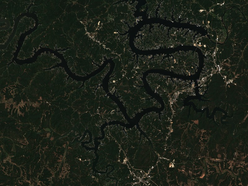
Copernicus Sentinel-2

Latest Satellite Image of Lake of the Ozarks

A true-colour image from the most recent low-cloud Sentinel-2 pass over the lake. It shows the lake as it looked on the capture date, not today.

Captured 2026-10-22 (0% cloud cover in scene)
Sentinel-2 true-colour satellite image of Lake of the Ozarks captured 2026-10-22
10 m/px β€’ Level-2A surface reflectanceOpen full image β†—

Contains modified Copernicus Sentinel data 2026, processed via the Copernicus Data Space Ecosystem.

Living Near Lake of the Ozarks

Shoreline and docks. Shoreline use on Lake of the Ozarks is managed by Ameren Missouri. Whether private docks are allowed, and where, depends on that operator's shoreline rules. Before making an offer on waterfront property, confirm with the operator whether a dock permit exists and whether it transfers to a new owner.

Flood pool and easements. Property near the water may carry flowage easements that limit building below a set elevation. Check the deed, a survey and the operator's rules before buying.

Nearby towns. Osage Beach, MO, Lake Ozark, MO, Camdenton, MO. Property taxes, utilities, HOA covenants and short-term rental rules vary between towns and counties.

Lakefront Living & Property

Living on Lake of the Ozarks

Considering a lake cabin, waterfront home, or retirement property on Lake of the Ozarks? Water levels, dock permits, and flood pool limits all affect waterfront property, so review them before you buy.

πŸ“

Osage Beach, MO

πŸ“

Lake Ozark, MO

πŸ“

Camdenton, MO

πŸ“

Sunrise Beach, MO

Nearby Lakes

862.17 ft MSL Below normal
Updated
-4.83 ft vs top of multipurpose pool (867.00 ft) USACE Stockton Lake Water Control Manual Β· checked 2026-09-29
24h change: -0.05 ft
Stockton Lake water level
910.52 ft MSL Observed level
Updated
Seasonal target: 917.00 ft Β· U.S. Army Corps of Engineers (SWL) Β· checked 2026-11-04 Β· schedule 2026-01-01 through 2026-12-31
24h change: 0.08 ft
Table Rock Lake water level
652.71 ft MSL Observed level
Updated
Seasonal target: 659.00 ft Β· U.S. Army Corps of Engineers (SWL) Β· checked 2026-11-04 Β· schedule 2026-01-01 through 2026-12-31
24h change: 0.14 ft
Bull Shoals Lake water level
552.18 ft MSL Observed level
Updated
Seasonal target: 553.75 ft Β· U.S. Army Corps of Engineers (SWL) Β· checked 2026-11-04 Β· schedule 2026-01-01 through 2026-12-31
24h change: 0.10 ft
Norfork Lake water level
1111.71 ft MSL Observed level
Updated
Seasonal target: 1120.43 ft Β· U.S. Army Corps of Engineers (SWL) Β· checked 2026-11-04 Β· schedule 2026-01-01 through 2026-12-31
24h change: 0.10 ft
Beaver Lake water level
741.97 ft MSL Near normal
Updated
-0.03 ft vs normal pool (742.00 ft) U.S. Army Corps of Engineers (SWT) Β· checked 2026-11-04
24h change: 0.06 ft
Water temperature: 67Β°F Β· Agency report Β· Β· Oklahoma Department of Wildlife Conservation
Grand Lake o' the Cherokees water level
454.82 ft MSL Observed level
Updated
Seasonal target: 462.04 ft Β· U.S. Army Corps of Engineers (SWL) Β· checked 2026-11-04 Β· schedule 2026-01-01 through 2026-12-31
24h change: 0.10 ft
Greers Ferry Lake water level
640.46 ft MSL In flood pool
Updated
2.46 ft vs normal pool (638.00 ft) U.S. Army Corps of Engineers (SWT) Β· checked 2026-11-04
24h change: -0.06 ft
Oologah Lake water level