
Lake Ouachita
U.S. Army Corps of Engineers, Vicksburg District • Dam completed 1953 • 40,000 surface acres
Lake-specific guide · Agency-sourced
Lake Ouachita: island water, wooded cover and ways to explore
A mountain reservoir with room to choose
Lake Ouachita spreads through the Ouachita Mountains of Arkansas behind Blakely Mountain Dam. The U.S. Army Corps of Engineers describes roughly 40,000 acres of water and many islands. That published area conveys the scale of the reservoir, not the distance to a safe landing or the amount of water around an island on a particular day. A boat trip among islands requires a different plan from an afternoon at a developed swim beach; neither trip is a substitute for checking current conditions.
The Corps manages a mix of developed campgrounds and more primitive recreation areas. Rather than assuming all shoreline is equally serviced, pick a destination based on whether you need a reserved campsite, a launch, a marked trail or a place to swim. The Corps’ lake information also describes camping on islands under its rules. Anyone considering that option should read the operator’s current requirements, check weather and water levels, and plan to pack out everything brought ashore.
Different cover in the upper and lower lake
Ouachita’s fishing habitat is not uniform. The Corps’ fishing description says much of the upper third has little natural cover because trees were cleared during construction, while standing timber remains in lower sections. It also describes brush piles, drop-offs, submerged humps and shallow rock outcrops. This makes an open-water plan unlike a trip focused on timber or rocky cover. Use a map and pay attention to underwater hazards; visible shoreline alone does not reveal the bottom.
The same agency lists species including largemouth and spotted bass, striped and white bass, walleye, crappie and catfish. The Arkansas Game and Fish Commission’s Rabbit Tail guide points to standing timber and steep banks in coves as places to consider for fishing. Neither agency description promises a bite today. Select a kind of water and cover first, then consult the current Arkansas fishing guide for applicable rules and a recent report before deciding how to fish it.
Explore from water or from shore
One unusually specific way to explore is the Corps’ Ouachita Geo-Float Trail, a self-guided, water-based interpretation route between the Spillway and Brady Mountain recreation areas. Marked stops explain the geology visible from the water. The Corps cautions that low water can bring rocks, stumps and other obstructions closer to a boat’s hull; the trail’s existence is not a signal that passage is safe at every level or in every weather condition.
For a paddle rather than a motorboat outing, AGFC’s Rabbit Tail Water Trail describes an 8.5-mile loop and the coves around its access. Its route length makes it worth considering daylight, wind, ability and a return plan rather than treating it as a quick lap. On shore, the Corps describes hiking and other recreation near developed parks. Check the trail operator’s route guidance and current access before setting out.
Start with an access point, not just a lake name
Brady Mountain Campground lists a boat ramp and swimming beach alongside reservable camping. Crystal Springs Campground also lists a ramp and swim beach. Their separate reservation pages are the right places to confirm the site, available dates and park-specific facilities. Neither campground listing guarantees that its ramp will work at any particular water elevation, so ask the operator about current launch conditions before towing a boat.
The island setting makes shoreline care especially practical: carry out litter, avoid damaging vegetation, and leave campsites ready for the next visitor. If weather, access or verified information about a destination is uncertain, use a developed park and shorten the plan rather than assuming an island landing will be straightforward. A time-stamped lake reading and an agency access notice answer different questions; use both where available.
Sources reviewed September 2026. Check current levels and operator notices before visiting.
Lake Ouachita Boat Ramps, Campgrounds & Marinas
Each site below links to the official listing it came from. Ramp closures depend on each ramp's design and the lake level, and most operators don't publish them in real time, so confirm with U.S. Army Corps of Engineers, Vicksburg District before you launch.
Campgrounds & RV Parks
Campgrounds listed by Recreation.gov and official park sources⛺ Air National Guard Camp
Check with operator⛺ Avery
Check with operatorAvery Recreation Area sits just below Blakely Mountain Dam and along the western shore of the Ouachita River/ Lake Hamilton. This day-use area offers great shoreline fishing access, an ADA fishing pier, boat ram...
⛺ Brady Mountain
Check with operatorBrady Mountain Campground delights visitors with its family-friendly facilities, fabulous views and idyllic placement on Arkansas's Lake Ouachita. The lake attracts visitors who come for the crystal clear waters...
⛺ Brady Mountain Day-Use
Check with operatorBrady Mountain Day-Use Area delights visitors with its family-friendly facility, fabulous views and idyllic placement on Arkansas's Lake Ouachita. The lake attracts visitors who come for the crystal clear waters...
⛺ Charlton Recreation Area
Check with operatorCharlton Campground is located 17-miles west of Hot Springs National Park along Highway 270-West. This historic campground constructed by the Civilian Conservation Corps (CCC) in the 1930's has been upgraded wit...
⛺ Crystal Springs (Ar)
Check with operatorCrystal Springs Campground, perched on the shores of Lake Ouachita in Arkansas, is an ideal spot for families, friends and couples. Approximately 1.2 million people visit the lake each year to explore its crysta...
⛺ Crystal Springs (Ar) Day-Use
Check with operatorCrystal Springs Day-Use Area, perched on the shores of Lake Ouachita in Arkansas, is an ideal spot for families, friends and couples. Approximately 1.2 million people visit the lake each year to explore its crys...
⛺ Denby Point
Check with operatorGroups and families of all sizes come to camp at Denby Point for its scenic views, year-round fishing and convenient boating facilities. The campground promises to entertain jet skiers, boaters, hikers and birde...
⛺ Highway 27 Campground
Check with operator⛺ Joplin
Check with operatorJoplin Campground on Lake Ouachita is an excellent destination for pristine lakefront camping. Joplin is perched on a slender peninsula with plenty of attractive scenic views of the water and surrounding mountai...
⛺ Little Fir
Check with operatorLittle Fir is a small quiet campground located along the western shores of Lake Ouachita. Little fir is a popular destination for many anglers who desire a quiet atmosphere while still being close to prime fishi...
⛺ Little Fir Recreation Area
Check with operator⛺ Spillway (Lake Ouachita)
Check with operatorSpillway Recreation area is tucked away in a small cove of Lake Ouachita. The day-use area offers shoreline fishing access, swim beach, restroom, boat ramp, reservable pavilion and access to the Lake Ouachita Vi...
⛺ Stephens Park
Check with operatorLocated just below Blakely Mountain Dam along the shoreline Lake Hamilton is Stephens Park. This small quiet campground has great shoreline fishing access in the Stephens Park and Avery Day-use Area. There is al...
⛺ Stephens Park Day-Use
Check with operatorLocated just below Blakely Mountain Dam along the shoreline Lake Hamilton is Stephens Park Day-Use Area. This area has great shoreline fishing. There is also boat ramp access nearby for Lake Ouachita by using th...
⛺ Tompkins Bend
Check with operatorTompkins Bend on Lake Ouachita, is a great family camping destination. The combination of lush mountain scenery and roomy sites big enough for two camping units, make this quiet location an ideal place for an ou...
⛺ Tompkins Bend Day-Use
Check with operatorTompkins Bend Day-Use Area on Lake Ouachita, is a great spot to getaway for the day. The combination of lush mountain scenery and wildlife, make this quiet location an ideal place for a family gathering, reunion...
⛺ Twin Creek Recreation Area
Check with operatorMarinas
Marinas on the lake. Contact each marina for services and rates.⚓ Brady Mountain Resort And Marina
⚓ Crystal Springs Resort
⚓ Echo Canyon Resort And Marina
⚓ Mountain Harbor Resort And Spa
⚓ North Shores Resort And Marina
⚓ Shangri La Resort
Parks & Day-Use Areas
Listed by Recreation.gov. Facilities vary; check each park's page for boat launch access.🌳 Cedar Fourche
🌳 Fulton Branch Day Use
River access on Ouachita River.
🌳 Highway 27 Fishing Village
🌳 Lake Ouachita State Park
🌳 Lake Ouachita Vista Overlook
Scenic view of Lake Ouachita. It's also one of the many points of interest along the Lake Ouachita Vista Trail. Other recreation sites in the Caddo/Womble Ranger District.
🌳 Little Fir Landing
Fishing Lake Ouachita
Lake Ouachita Fishing Report
Waning Crescent (20% illuminated); strongest solunar period: Moon Overhead 7:26 AM–9:26 AM CST; lake at 568.70 ft, 9.3 ft below normal pool, up 0.18 ft in 24 hours.
Official Fishing Reports
Latest report for Lake Ouachita: Arkansas Game and Fish Commission, Oct 29, 2026 →
Fishing & Boating Rules
Official SourcesLimits, licenses, and boating requirements change often. Check the current official rules before fishing or boating on Lake Ouachita:
Report Conditions on Lake Ouachita
Seen a hazard, a ramp closure, or changing water clarity? Reports go to LakeWatchers for review.
Were you on the water today?
Tell us about water clarity, ramp conditions, or hazards. We review reports and use them to correct the information on this page.
Latest Satellite Image of Lake Ouachita
A true-colour image from the most recent low-cloud Sentinel-2 pass over the lake. It shows the lake as it looked on the capture date, not today.
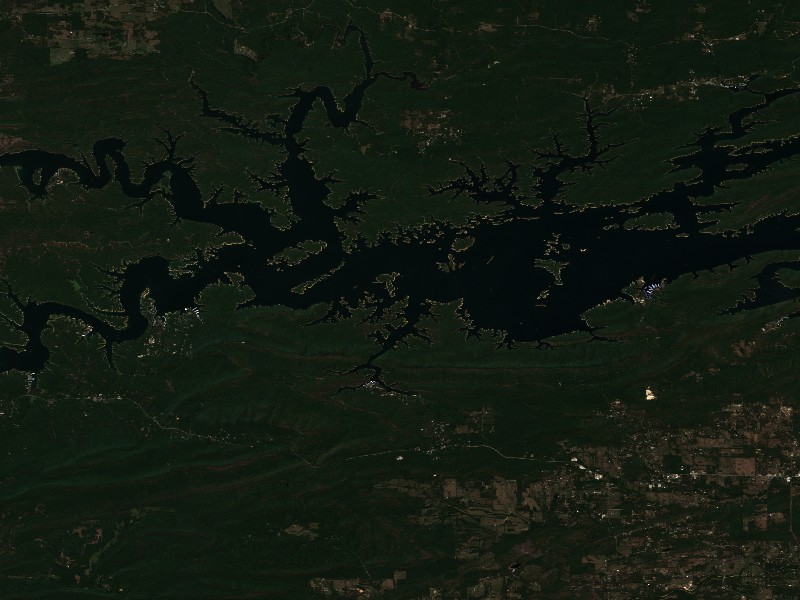
Contains modified Copernicus Sentinel data 2026, processed via the Copernicus Data Space Ecosystem.
Commercial Marinas & Featured Partners on Lake Ouachita
Marinas from official listings, plus open spots for local guides and rental operators.
⚓ Brady Mountain Resort And Marina
⚓ Crystal Springs Resort
Charter Guide or Boat Rental on Lake Ouachita?
Reach boaters and anglers checking water levels and boat ramp listings before heading to Lake Ouachita.
Living Near Lake Ouachita
Shoreline and docks. Shoreline use on Lake Ouachita is managed by U.S. Army Corps of Engineers, Vicksburg District. Whether private docks are allowed, and where, depends on that operator's shoreline rules. Before making an offer on waterfront property, confirm with the operator whether a dock permit exists and whether it transfers to a new owner.
Flood pool and easements. The normal pool is 578.00 ft MSL and the flood pool reaches 592.00 ft MSL, a 14 ft difference. Property near the water may carry flowage easements that limit building below a set elevation. Check the deed, a survey and the operator's rules before buying.
Nearby towns. Hot Springs, AR, Mount Ida, AR. Property taxes, utilities, HOA covenants and short-term rental rules vary between towns and counties.
Living on Lake Ouachita
Considering a lake cabin, waterfront home, or retirement property on Lake Ouachita? Water levels, dock permits, and flood pool limits all affect waterfront property, so review them before you buy.
Hot Springs, AR
Mount Ida, AR
Mountain Pine, AR
Hot Springs Village, AR
Nearby Lakes
Norfork Lake
AR/MOTable Rock Lake
MO/ARWeekend trip planning: Lakes Near Tulsa, OK · Lakes Near Little Rock, AR